You are here: Home > Network List > TA - USArray Transportable Network (new EarthScope stations) Stations List
> Station M04C Macdoel, CA, USA > Earthquake Result Viewer
M04C Macdoel, CA, USA - Earthquake Result Viewer
| Earthquake location: |
Vanuatu Islands |
| Earthquake latitude/longitude: |
-13.9/167.2 |
| Earthquake time(UTC): |
2014/01/01 (001) 16:03:29 GMT |
| Earthquake Depth: |
187 km |
| Earthquake Magnitude: |
6.5 MWW, 6.5 MWC, 6.6 MWC, 6.6 MI, 6.6 MWB |
| Earthquake Catalog/Contributor: |
NEIC PDE/NEIC COMCAT |
|
| Network: |
TA USArray Transportable Network (new EarthScope stations) |
| Station: |
M04C Macdoel, CA, USA |
| Lat/Lon: |
41.78 N/121.84 W |
| Elevation: |
1391 m |
|
| Distance: |
85.4 deg |
| Az: |
45.155 deg |
| Baz: |
247.036 deg |
| Ray Param: |
0.044326786 |
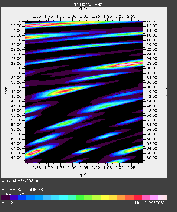
| Estimated Moho Depth: |
28.0 km |
| Estimated Crust Vp/Vs: |
2.04 |
| Assumed Crust Vp: |
6.566 km/s |
| Estimated Crust Vs: |
3.223 km/s |
| Estimated Crust Poisson's Ratio: |
0.34 |
|
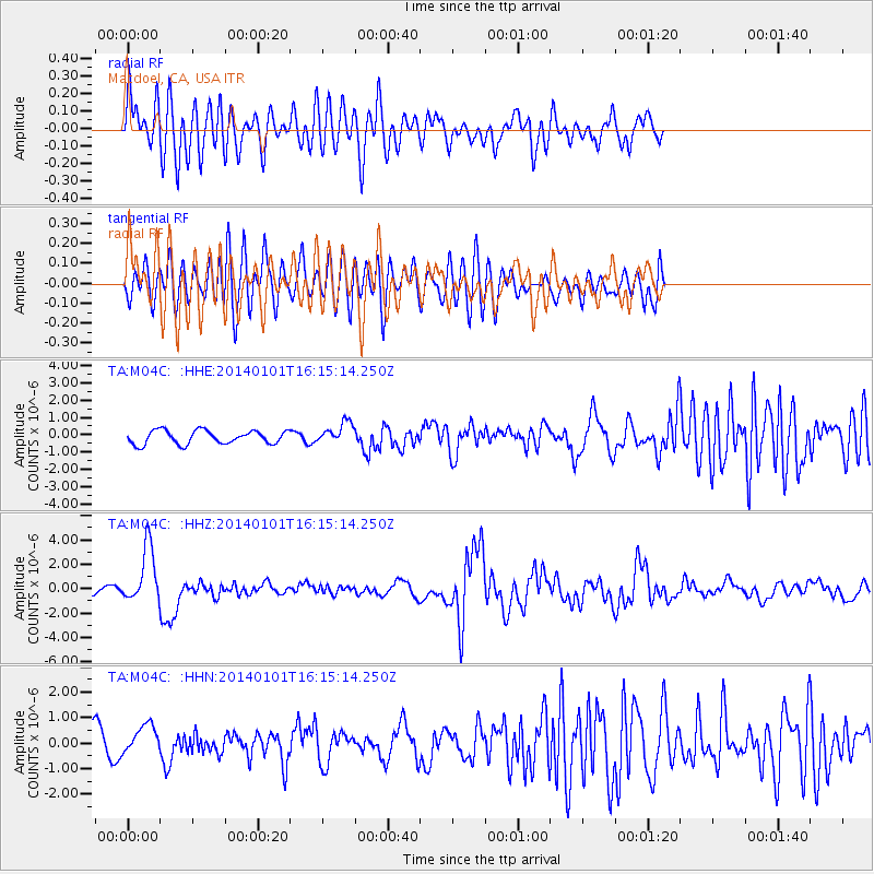
| Radial Match: |
84.65846 % |
| Radial Bump: |
400 |
| Transverse Match: |
78.4144 % |
| Transverse Bump: |
400 |
| SOD ConfigId: |
626651 |
| Insert Time: |
2014-04-20 06:18:46.997 +0000 |
| GWidth: |
2.5 |
| Max Bumps: |
400 |
| Tol: |
0.001 |
|
Signal To Noise
| Channel | StoN | STA | LTA |
| TA:M04C: :HHZ:20140101T16:15:14.250Z | 10.612298 | 2.3082944E-6 | 2.1751126E-7 |
| TA:M04C: :HHN:20140101T16:15:14.250Z | 1.4298174 | 5.8754154E-7 | 4.1092068E-7 |
| TA:M04C: :HHE:20140101T16:15:14.250Z | 1.5658985 | 6.035295E-7 | 3.8542058E-7 |
| Arrivals |
| Ps | 4.5 SECOND |
| PpPs | 13 SECOND |
| PsPs/PpSs | 17 SECOND |


