You are here: Home > Network List > TA - USArray Transportable Network (new EarthScope stations) Stations List
> Station O03E Paynes Creek, CA, USA > Earthquake Result Viewer
O03E Paynes Creek, CA, USA - Earthquake Result Viewer
| Earthquake location: |
Vanuatu Islands |
| Earthquake latitude/longitude: |
-13.9/167.2 |
| Earthquake time(UTC): |
2014/01/01 (001) 16:03:29 GMT |
| Earthquake Depth: |
187 km |
| Earthquake Magnitude: |
6.5 MWW, 6.5 MWC, 6.6 MWC, 6.6 MI, 6.6 MWB |
| Earthquake Catalog/Contributor: |
NEIC PDE/NEIC COMCAT |
|
| Network: |
TA USArray Transportable Network (new EarthScope stations) |
| Station: |
O03E Paynes Creek, CA, USA |
| Lat/Lon: |
40.29 N/121.80 W |
| Elevation: |
967 m |
|
| Distance: |
84.9 deg |
| Az: |
46.54 deg |
| Baz: |
247.178 deg |
| Ray Param: |
0.044716615 |
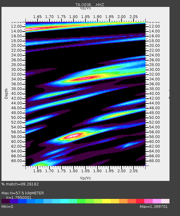
| Estimated Moho Depth: |
57.5 km |
| Estimated Crust Vp/Vs: |
1.80 |
| Assumed Crust Vp: |
6.566 km/s |
| Estimated Crust Vs: |
3.658 km/s |
| Estimated Crust Poisson's Ratio: |
0.27 |
|
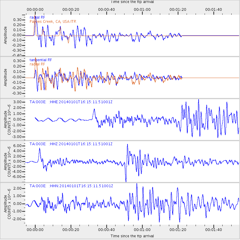
| Radial Match: |
89.26162 % |
| Radial Bump: |
400 |
| Transverse Match: |
81.15279 % |
| Transverse Bump: |
378 |
| SOD ConfigId: |
626651 |
| Insert Time: |
2014-04-20 06:18:59.601 +0000 |
| GWidth: |
2.5 |
| Max Bumps: |
400 |
| Tol: |
0.001 |
|
Signal To Noise
| Channel | StoN | STA | LTA |
| TA:O03E: :HHZ:20140101T16:15:11.51001Z | 14.54182 | 1.8842004E-6 | 1.2957116E-7 |
| TA:O03E: :HHN:20140101T16:15:11.51001Z | 1.9080459 | 3.82392E-7 | 2.0041026E-7 |
| TA:O03E: :HHE:20140101T16:15:11.51001Z | 3.8526742 | 7.1944277E-7 | 1.8673853E-7 |
| Arrivals |
| Ps | 7.1 SECOND |
| PpPs | 24 SECOND |
| PsPs/PpSs | 31 SECOND |


