You are here: Home > Network List > US - United States National Seismic Network Stations List
> Station EGMT Eagleton, Montana, USA > Earthquake Result Viewer
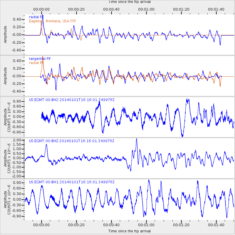
EGMT Eagleton, Montana, USA - Earthquake Result Viewer
*The percent match for this event was below the threshold and hence no stack was calculated.
| Earthquake location: |
Vanuatu Islands |
| Earthquake latitude/longitude: |
-13.9/167.2 |
| Earthquake time(UTC): |
2014/01/01 (001) 16:03:29 GMT |
| Earthquake Depth: |
187 km |
| Earthquake Magnitude: |
6.5 MWW, 6.5 MWC, 6.6 MWC, 6.6 MI, 6.6 MWB |
| Earthquake Catalog/Contributor: |
NEIC PDE/NEIC COMCAT |
|
| Network: |
US United States National Seismic Network |
| Station: |
EGMT Eagleton, Montana, USA |
| Lat/Lon: |
48.02 N/109.75 W |
| Elevation: |
1055 m |
|
| Distance: |
95.6 deg |
| Az: |
42.024 deg |
| Baz: |
255.595 deg |
| Ray Param: |
$rayparam |
*The percent match for this event was below the threshold and hence was not used in the summary stack. |
|
| Radial Match: |
57.034203 % |
| Radial Bump: |
400 |
| Transverse Match: |
42.868504 % |
| Transverse Bump: |
316 |
| SOD ConfigId: |
626651 |
| Insert Time: |
2014-04-20 06:19:58.818 +0000 |
| GWidth: |
2.5 |
| Max Bumps: |
400 |
| Tol: |
0.001 |
|
Signal To Noise
| Channel | StoN | STA | LTA |
| US:EGMT:00:BHZ:20140101T16:16:01.349976Z | 5.4716706 | 6.4682274E-7 | 1.1821302E-7 |
| US:EGMT:00:BH1:20140101T16:16:01.349976Z | 1.4424263 | 4.302053E-7 | 2.9825114E-7 |
| US:EGMT:00:BH2:20140101T16:16:01.349976Z | 3.2724154 | 5.5414085E-7 | 1.6933694E-7 |
| Arrivals |
| Ps | |
| PpPs | |
| PsPs/PpSs | |


