You are here: Home > Network List > UU - University of Utah Regional Network Stations List
> Station KNB Kanab, UT, USA > Earthquake Result Viewer
KNB Kanab, UT, USA - Earthquake Result Viewer
| Earthquake location: |
Vanuatu Islands |
| Earthquake latitude/longitude: |
-13.9/167.2 |
| Earthquake time(UTC): |
2014/01/01 (001) 16:03:29 GMT |
| Earthquake Depth: |
187 km |
| Earthquake Magnitude: |
6.5 MWW, 6.5 MWC, 6.6 MWC, 6.6 MI, 6.6 MWB |
| Earthquake Catalog/Contributor: |
NEIC PDE/NEIC COMCAT |
|
| Network: |
UU University of Utah Regional Network |
| Station: |
KNB Kanab, UT, USA |
| Lat/Lon: |
37.02 N/112.82 W |
| Elevation: |
1715 m |
|
| Distance: |
90.4 deg |
| Az: |
52.007 deg |
| Baz: |
252.999 deg |
| Ray Param: |
0.04163632 |
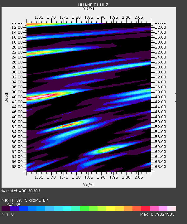
| Estimated Moho Depth: |
39.75 km |
| Estimated Crust Vp/Vs: |
1.65 |
| Assumed Crust Vp: |
6.194 km/s |
| Estimated Crust Vs: |
3.754 km/s |
| Estimated Crust Poisson's Ratio: |
0.21 |
|
| Radial Match: |
90.68686 % |
| Radial Bump: |
400 |
| Transverse Match: |
80.537994 % |
| Transverse Bump: |
400 |
| SOD ConfigId: |
626651 |
| Insert Time: |
2014-04-20 06:21:05.308 +0000 |
| GWidth: |
2.5 |
| Max Bumps: |
400 |
| Tol: |
0.001 |
|
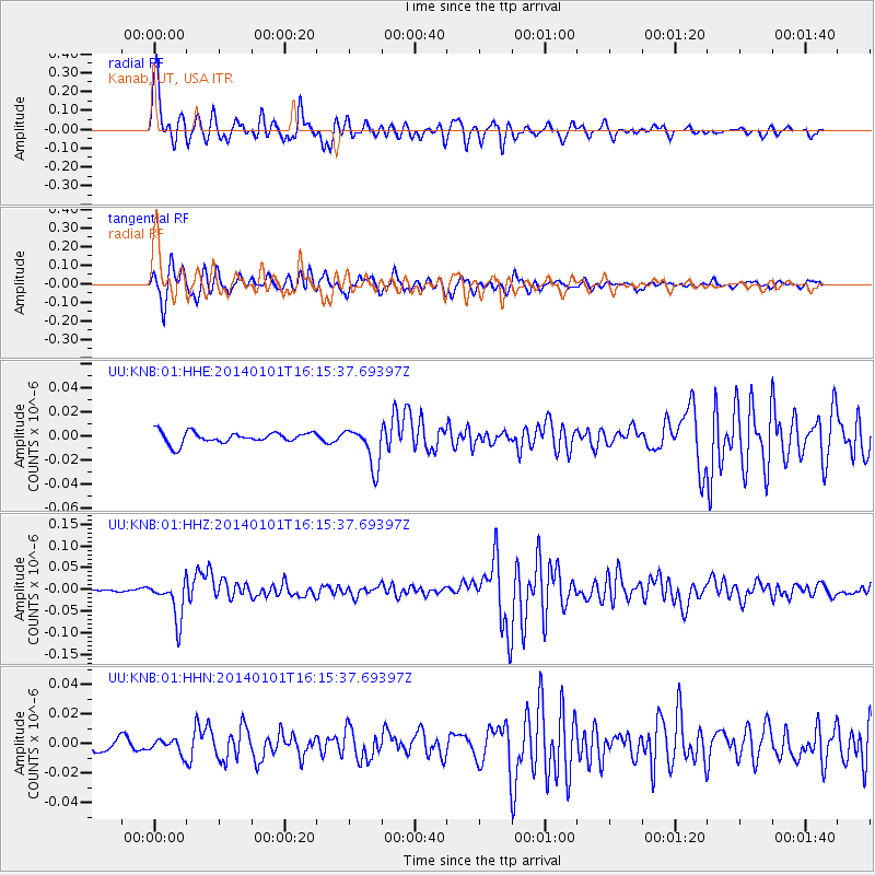
Signal To Noise
| Channel | StoN | STA | LTA |
| UU:KNB:01:HHZ:20140101T16:15:37.69397Z | 15.180916 | 4.5740332E-8 | 3.0130154E-9 |
| UU:KNB:01:HHN:20140101T16:15:37.69397Z | 1.0434691 | 4.63246E-9 | 4.4394803E-9 |
| UU:KNB:01:HHE:20140101T16:15:37.69397Z | 3.598583 | 1.6780236E-8 | 4.6630118E-9 |
| Arrivals |
| Ps | 4.3 SECOND |
| PpPs | 17 SECOND |
| PsPs/PpSs | 21 SECOND |


