You are here: Home > Network List > TA - USArray Transportable Network (new EarthScope stations) Stations List
> Station 121A Cookes Peak, Deming, NM, USA > Earthquake Result Viewer
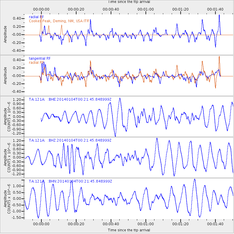
121A Cookes Peak, Deming, NM, USA - Earthquake Result Viewer
*The percent match for this event was below the threshold and hence no stack was calculated.
| Earthquake location: |
Near Coast Of Northern Chile |
| Earthquake latitude/longitude: |
-20.7/-70.8 |
| Earthquake time(UTC): |
2014/01/04 (004) 00:11:48 GMT |
| Earthquake Depth: |
26 km |
| Earthquake Magnitude: |
5.7 MWW, 5.8 MWB, 5.8 MWC |
| Earthquake Catalog/Contributor: |
NEIC PDE/NEIC COMCAT |
|
| Network: |
TA USArray Transportable Network (new EarthScope stations) |
| Station: |
121A Cookes Peak, Deming, NM, USA |
| Lat/Lon: |
32.53 N/107.79 W |
| Elevation: |
1652 m |
|
| Distance: |
63.7 deg |
| Az: |
325.448 deg |
| Baz: |
141.05 deg |
| Ray Param: |
$rayparam |
*The percent match for this event was below the threshold and hence was not used in the summary stack. |
|
| Radial Match: |
55.1268 % |
| Radial Bump: |
400 |
| Transverse Match: |
80.15829 % |
| Transverse Bump: |
400 |
| SOD ConfigId: |
626651 |
| Insert Time: |
2014-04-20 06:36:51.779 +0000 |
| GWidth: |
2.5 |
| Max Bumps: |
400 |
| Tol: |
0.001 |
|
Signal To Noise
| Channel | StoN | STA | LTA |
| TA:121A: :BHZ:20140104T00:21:45.848999Z | 1.1975634 | 3.4945347E-7 | 2.9180376E-7 |
| TA:121A: :BHN:20140104T00:21:45.848999Z | 1.8279926 | 1.0239452E-6 | 5.601474E-7 |
| TA:121A: :BHE:20140104T00:21:45.848999Z | 1.9033173 | 4.1954647E-7 | 2.2042907E-7 |
| Arrivals |
| Ps | |
| PpPs | |
| PsPs/PpSs | |


