You are here: Home > Network List > IU - Global Seismograph Network (GSN - IRIS/USGS) Stations List
> Station POHA Pohakuloa, Hawaii, USA > Earthquake Result Viewer
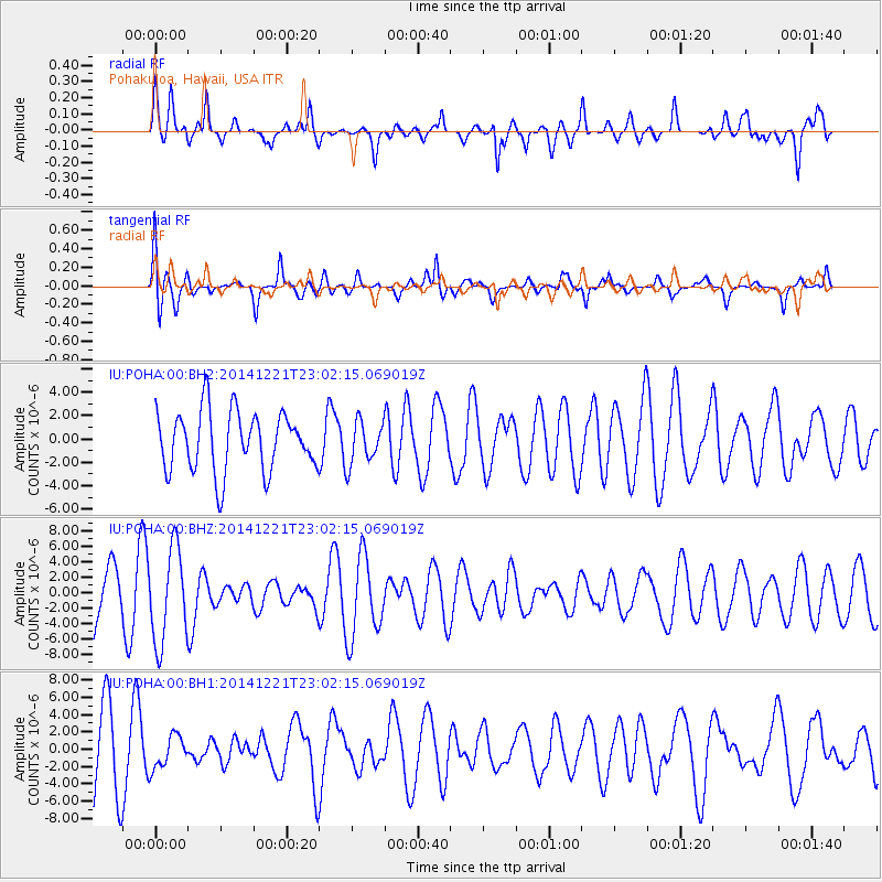
POHA Pohakuloa, Hawaii, USA - Earthquake Result Viewer
*The percent match for this event was below the threshold and hence no stack was calculated.
| Earthquake location: |
Southeast Of Loyalty Islands |
| Earthquake latitude/longitude: |
-22.7/173.4 |
| Earthquake time(UTC): |
2014/12/21 (355) 22:53:42 GMT |
| Earthquake Depth: |
62 km |
| Earthquake Magnitude: |
3.2 mb, 3.6 mb1, 3.4 mb1mx, 3.6 mbtmp, 5.9 ML, 3.3 MS, 3.3 Ms1, 2.8 ms1mx |
| Earthquake Catalog/Contributor: |
ISC/ISC |
|
| Network: |
IU Global Seismograph Network (GSN - IRIS/USGS) |
| Station: |
POHA Pohakuloa, Hawaii, USA |
| Lat/Lon: |
19.76 N/155.53 W |
| Elevation: |
1990 m |
|
| Distance: |
52.0 deg |
| Az: |
38.103 deg |
| Baz: |
217.218 deg |
| Ray Param: |
$rayparam |
*The percent match for this event was below the threshold and hence was not used in the summary stack. |
|
| Radial Match: |
46.535393 % |
| Radial Bump: |
400 |
| Transverse Match: |
63.15259 % |
| Transverse Bump: |
400 |
| SOD ConfigId: |
3390531 |
| Insert Time: |
2019-04-15 18:09:08.402 +0000 |
| GWidth: |
2.5 |
| Max Bumps: |
400 |
| Tol: |
0.001 |
|
Signal To Noise
| Channel | StoN | STA | LTA |
| IU:POHA:00:BHZ:20141221T23:02:15.069019Z | 2.2656121 | 6.0793404E-6 | 2.6833104E-6 |
| IU:POHA:00:BH1:20141221T23:02:15.069019Z | 0.47768256 | 1.8620424E-6 | 3.8980747E-6 |
| IU:POHA:00:BH2:20141221T23:02:15.069019Z | 0.7069229 | 1.8090121E-6 | 2.558995E-6 |
| Arrivals |
| Ps | |
| PpPs | |
| PsPs/PpSs | |


