You are here: Home > Network List > TA - USArray Transportable Network (new EarthScope stations) Stations List
> Station 833A Chaparral WMA, Artesia Wells, TX, USA > Earthquake Result Viewer
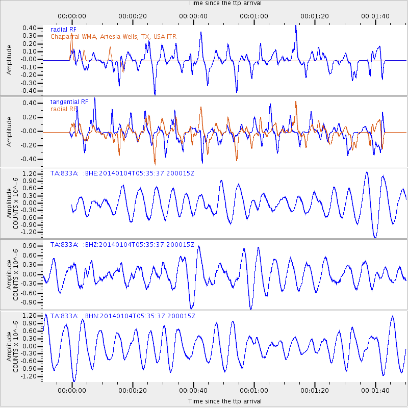
833A Chaparral WMA, Artesia Wells, TX, USA - Earthquake Result Viewer
*The percent match for this event was below the threshold and hence no stack was calculated.
| Earthquake location: |
Off East Coast Of Honshu, Japan |
| Earthquake latitude/longitude: |
37.0/143.4 |
| Earthquake time(UTC): |
2014/01/04 (004) 05:23:00 GMT |
| Earthquake Depth: |
22 km |
| Earthquake Magnitude: |
5.5 MWB |
| Earthquake Catalog/Contributor: |
NEIC PDE/NEIC COMCAT |
|
| Network: |
TA USArray Transportable Network (new EarthScope stations) |
| Station: |
833A Chaparral WMA, Artesia Wells, TX, USA |
| Lat/Lon: |
28.32 N/99.39 W |
| Elevation: |
171 m |
|
| Distance: |
92.3 deg |
| Az: |
51.683 deg |
| Baz: |
314.541 deg |
| Ray Param: |
$rayparam |
*The percent match for this event was below the threshold and hence was not used in the summary stack. |
|
| Radial Match: |
57.092026 % |
| Radial Bump: |
381 |
| Transverse Match: |
52.176006 % |
| Transverse Bump: |
323 |
| SOD ConfigId: |
626651 |
| Insert Time: |
2014-04-20 07:05:26.952 +0000 |
| GWidth: |
2.5 |
| Max Bumps: |
400 |
| Tol: |
0.001 |
|
Signal To Noise
| Channel | StoN | STA | LTA |
| TA:833A: :BHZ:20140104T05:35:37.200015Z | 1.1525716 | 2.78468E-7 | 2.4160585E-7 |
| TA:833A: :BHN:20140104T05:35:37.200015Z | 1.6413978 | 8.53927E-7 | 5.202438E-7 |
| TA:833A: :BHE:20140104T05:35:37.200015Z | 1.1546344 | 4.0911112E-7 | 3.5432095E-7 |
| Arrivals |
| Ps | |
| PpPs | |
| PsPs/PpSs | |


