You are here: Home > Network List > TA - USArray Transportable Network (new EarthScope stations) Stations List
> Station I59A Olmsteadville, NY, USA > Earthquake Result Viewer
I59A Olmsteadville, NY, USA - Earthquake Result Viewer
| Earthquake location: |
Off East Coast Of Honshu, Japan |
| Earthquake latitude/longitude: |
37.0/143.4 |
| Earthquake time(UTC): |
2014/01/04 (004) 05:23:00 GMT |
| Earthquake Depth: |
22 km |
| Earthquake Magnitude: |
5.5 MWB |
| Earthquake Catalog/Contributor: |
NEIC PDE/NEIC COMCAT |
|
| Network: |
TA USArray Transportable Network (new EarthScope stations) |
| Station: |
I59A Olmsteadville, NY, USA |
| Lat/Lon: |
43.80 N/73.87 W |
| Elevation: |
390 m |
|
| Distance: |
92.8 deg |
| Az: |
26.034 deg |
| Baz: |
330.96 deg |
| Ray Param: |
0.041384213 |
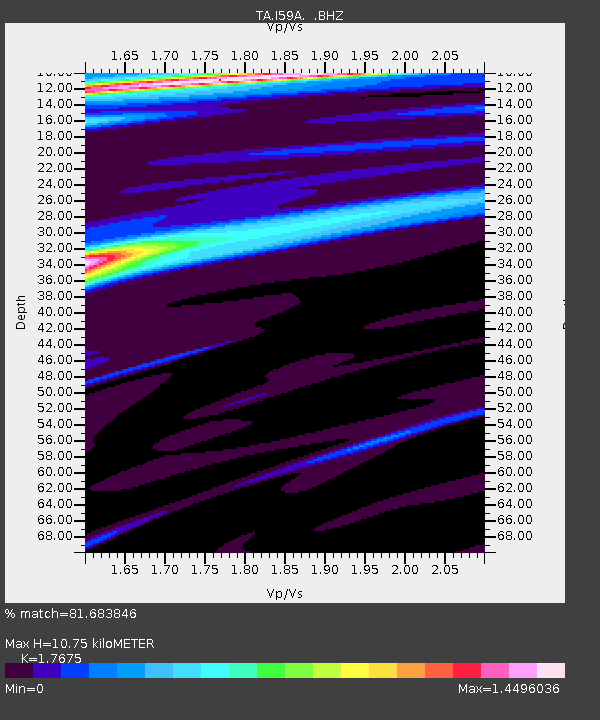
| Estimated Moho Depth: |
10.75 km |
| Estimated Crust Vp/Vs: |
1.77 |
| Assumed Crust Vp: |
6.419 km/s |
| Estimated Crust Vs: |
3.632 km/s |
| Estimated Crust Poisson's Ratio: |
0.26 |
|
| Radial Match: |
81.683846 % |
| Radial Bump: |
400 |
| Transverse Match: |
83.74121 % |
| Transverse Bump: |
342 |
| SOD ConfigId: |
626651 |
| Insert Time: |
2014-04-20 07:07:38.394 +0000 |
| GWidth: |
2.5 |
| Max Bumps: |
400 |
| Tol: |
0.001 |
|

Signal To Noise
| Channel | StoN | STA | LTA |
| TA:I59A: :BHZ:20140104T05:35:39.375002Z | 1.9054971 | 3.6974543E-6 | 1.9404147E-6 |
| TA:I59A: :BHN:20140104T05:35:39.375002Z | 0.8965476 | 1.3301303E-6 | 1.4836137E-6 |
| TA:I59A: :BHE:20140104T05:35:39.375002Z | 1.618643 | 2.1487958E-6 | 1.3275292E-6 |
| Arrivals |
| Ps | 1.3 SECOND |
| PpPs | 4.5 SECOND |
| PsPs/PpSs | 5.9 SECOND |


