You are here: Home > Network List > CI - Caltech Regional Seismic Network Stations List
> Station CIA CIA, Avalon Catalina Island, CA, USA > Earthquake Result Viewer
CIA CIA, Avalon Catalina Island, CA, USA - Earthquake Result Viewer
| Earthquake location: |
Kodiak Island Region, Alaska |
| Earthquake latitude/longitude: |
57.2/-151.0 |
| Earthquake time(UTC): |
2001/07/19 (200) 18:00:40 GMT |
| Earthquake Depth: |
33 km |
| Earthquake Magnitude: |
5.9 MB, 5.4 MS, 5.9 MW, 5.9 ML |
| Earthquake Catalog/Contributor: |
WHDF/NEIC |
|
| Network: |
CI Caltech Regional Seismic Network |
| Station: |
CIA CIA, Avalon Catalina Island, CA, USA |
| Lat/Lon: |
33.40 N/118.41 W |
| Elevation: |
467 m |
|
| Distance: |
32.5 deg |
| Az: |
123.001 deg |
| Baz: |
326.932 deg |
| Ray Param: |
0.07856365 |
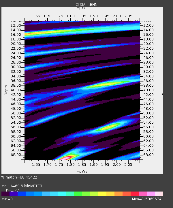
| Estimated Moho Depth: |
69.5 km |
| Estimated Crust Vp/Vs: |
1.77 |
| Assumed Crust Vp: |
6.048 km/s |
| Estimated Crust Vs: |
3.417 km/s |
| Estimated Crust Poisson's Ratio: |
0.27 |
|
| Radial Match: |
88.43422 % |
| Radial Bump: |
400 |
| Transverse Match: |
83.53512 % |
| Transverse Bump: |
400 |
| SOD ConfigId: |
3770 |
| Insert Time: |
2010-02-25 20:55:13.074 +0000 |
| GWidth: |
2.5 |
| Max Bumps: |
400 |
| Tol: |
0.001 |
|
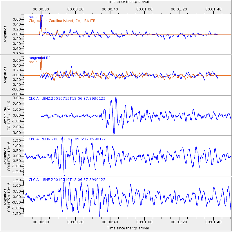
Signal To Noise
| Channel | StoN | STA | LTA |
| CI:CIA: :BHN:20010719T18:06:37.899012Z | 0.8848412 | 1.2819753E-7 | 1.4488195E-7 |
| CI:CIA: :BHE:20010719T18:06:37.899012Z | 1.263351 | 1.678785E-7 | 1.328835E-7 |
| CI:CIA: :BHZ:20010719T18:06:37.899012Z | 0.80291533 | 1.2155314E-7 | 1.5138974E-7 |
| Arrivals |
| Ps | 9.5 SECOND |
| PpPs | 30 SECOND |
| PsPs/PpSs | 39 SECOND |


