You are here: Home > Network List > TA - USArray Transportable Network (new EarthScope stations) Stations List
> Station T25A Trinidad, CO, USA > Earthquake Result Viewer
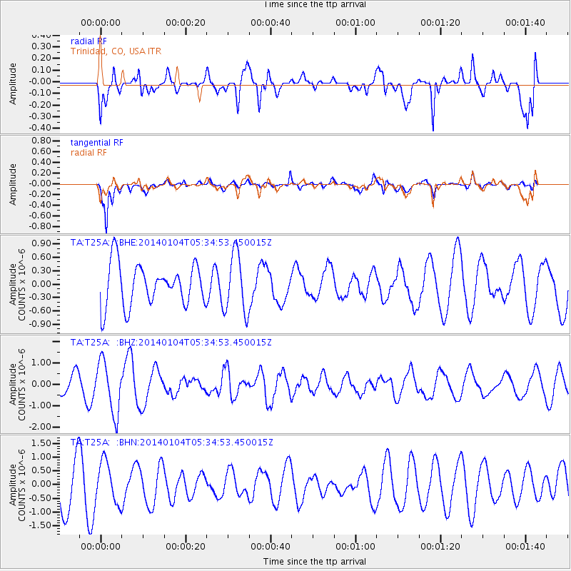
T25A Trinidad, CO, USA - Earthquake Result Viewer
*The percent match for this event was below the threshold and hence no stack was calculated.
| Earthquake location: |
Off East Coast Of Honshu, Japan |
| Earthquake latitude/longitude: |
37.0/143.4 |
| Earthquake time(UTC): |
2014/01/04 (004) 05:23:00 GMT |
| Earthquake Depth: |
22 km |
| Earthquake Magnitude: |
5.5 MWB |
| Earthquake Catalog/Contributor: |
NEIC PDE/NEIC COMCAT |
|
| Network: |
TA USArray Transportable Network (new EarthScope stations) |
| Station: |
T25A Trinidad, CO, USA |
| Lat/Lon: |
37.14 N/104.41 W |
| Elevation: |
2017 m |
|
| Distance: |
83.2 deg |
| Az: |
48.164 deg |
| Baz: |
311.695 deg |
| Ray Param: |
$rayparam |
*The percent match for this event was below the threshold and hence was not used in the summary stack. |
|
| Radial Match: |
61.43712 % |
| Radial Bump: |
400 |
| Transverse Match: |
78.91574 % |
| Transverse Bump: |
400 |
| SOD ConfigId: |
626651 |
| Insert Time: |
2014-04-20 07:11:17.975 +0000 |
| GWidth: |
2.5 |
| Max Bumps: |
400 |
| Tol: |
0.001 |
|
Signal To Noise
| Channel | StoN | STA | LTA |
| TA:T25A: :BHZ:20140104T05:34:53.450015Z | 2.452342 | 1.2339024E-6 | 5.0315265E-7 |
| TA:T25A: :BHN:20140104T05:34:53.450015Z | 0.9594356 | 7.6231316E-7 | 7.945433E-7 |
| TA:T25A: :BHE:20140104T05:34:53.450015Z | 1.4327387 | 6.7294013E-7 | 4.6968796E-7 |
| Arrivals |
| Ps | |
| PpPs | |
| PsPs/PpSs | |


