You are here: Home > Network List > YT07 - POLENET Stations List
> Station ALYS ALYS > Earthquake Result Viewer
ALYS ALYS - Earthquake Result Viewer
| Earthquake location: |
Pacific-Antarctic Ridge |
| Earthquake latitude/longitude: |
-54.2/-145.9 |
| Earthquake time(UTC): |
2014/12/22 (356) 07:19:41 GMT |
| Earthquake Depth: |
10 km |
| Earthquake Magnitude: |
5.8 MB |
| Earthquake Catalog/Contributor: |
NEIC PDE/NEIC COMCAT |
|
| Network: |
YT POLENET |
| Station: |
ALYS ALYS |
| Lat/Lon: |
84.35 S/23.73 W |
| Elevation: |
2084 m |
|
| Distance: |
39.3 deg |
| Az: |
172.401 deg |
| Baz: |
231.775 deg |
| Ray Param: |
0.07505486 |
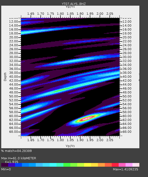
| Estimated Moho Depth: |
61.0 km |
| Estimated Crust Vp/Vs: |
1.93 |
| Assumed Crust Vp: |
6.356 km/s |
| Estimated Crust Vs: |
3.285 km/s |
| Estimated Crust Poisson's Ratio: |
0.32 |
|
| Radial Match: |
84.28389 % |
| Radial Bump: |
300 |
| Transverse Match: |
75.71163 % |
| Transverse Bump: |
400 |
| SOD ConfigId: |
3390531 |
| Insert Time: |
2019-04-15 18:15:58.626 +0000 |
| GWidth: |
2.5 |
| Max Bumps: |
400 |
| Tol: |
0.001 |
|

Signal To Noise
| Channel | StoN | STA | LTA |
| YT:ALYS: :BHZ:20141222T07:26:39.349005Z | 14.076515 | 1.7732627E-6 | 1.2597313E-7 |
| YT:ALYS: :BHN:20141222T07:26:39.349005Z | 7.566868 | 4.9099555E-7 | 6.488755E-8 |
| YT:ALYS: :BHE:20141222T07:26:39.349005Z | 5.3209662 | 7.790619E-7 | 1.4641363E-7 |
| Arrivals |
| Ps | 9.6 SECOND |
| PpPs | 26 SECOND |
| PsPs/PpSs | 36 SECOND |


