You are here: Home > Network List > TA - USArray Transportable Network (new EarthScope stations) Stations List
> Station L44A Lake County Forest Preserve, Grayslake, IL, USA > Earthquake Result Viewer
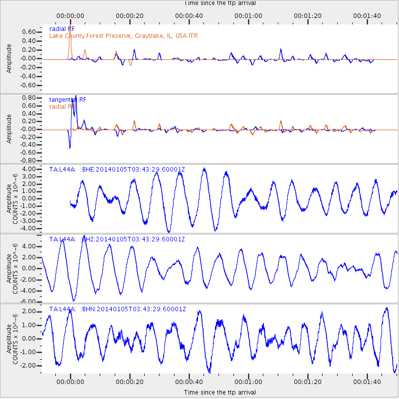
L44A Lake County Forest Preserve, Grayslake, IL, USA - Earthquake Result Viewer
*The percent match for this event was below the threshold and hence no stack was calculated.
| Earthquake location: |
Colombia |
| Earthquake latitude/longitude: |
4.6/-76.6 |
| Earthquake time(UTC): |
2014/01/05 (005) 03:36:40 GMT |
| Earthquake Depth: |
54 km |
| Earthquake Magnitude: |
5.5 MWB, 5.6 MWC |
| Earthquake Catalog/Contributor: |
NEIC PDE/NEIC COMCAT |
|
| Network: |
TA USArray Transportable Network (new EarthScope stations) |
| Station: |
L44A Lake County Forest Preserve, Grayslake, IL, USA |
| Lat/Lon: |
42.18 N/87.91 W |
| Elevation: |
202 m |
|
| Distance: |
38.8 deg |
| Az: |
346.594 deg |
| Baz: |
161.883 deg |
| Ray Param: |
$rayparam |
*The percent match for this event was below the threshold and hence was not used in the summary stack. |
|
| Radial Match: |
74.88905 % |
| Radial Bump: |
400 |
| Transverse Match: |
95.37194 % |
| Transverse Bump: |
365 |
| SOD ConfigId: |
626651 |
| Insert Time: |
2014-04-20 07:33:45.935 +0000 |
| GWidth: |
2.5 |
| Max Bumps: |
400 |
| Tol: |
0.001 |
|
Signal To Noise
| Channel | StoN | STA | LTA |
| TA:L44A: :BHZ:20140105T03:43:29.60001Z | 2.353406 | 3.974223E-6 | 1.6887113E-6 |
| TA:L44A: :BHN:20140105T03:43:29.60001Z | 1.8388395 | 1.3498395E-6 | 7.3407136E-7 |
| TA:L44A: :BHE:20140105T03:43:29.60001Z | 1.9917432 | 2.9011994E-6 | 1.4566132E-6 |
| Arrivals |
| Ps | |
| PpPs | |
| PsPs/PpSs | |


