You are here: Home > Network List > TA - USArray Transportable Network (new EarthScope stations) Stations List
> Station N50A Nevada, OH, USA > Earthquake Result Viewer
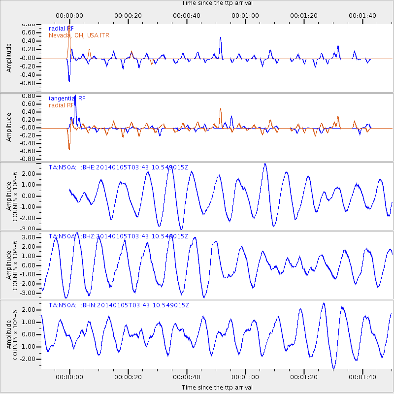
N50A Nevada, OH, USA - Earthquake Result Viewer
*The percent match for this event was below the threshold and hence no stack was calculated.
| Earthquake location: |
Colombia |
| Earthquake latitude/longitude: |
4.6/-76.6 |
| Earthquake time(UTC): |
2014/01/05 (005) 03:36:40 GMT |
| Earthquake Depth: |
54 km |
| Earthquake Magnitude: |
5.5 MWB, 5.6 MWC |
| Earthquake Catalog/Contributor: |
NEIC PDE/NEIC COMCAT |
|
| Network: |
TA USArray Transportable Network (new EarthScope stations) |
| Station: |
N50A Nevada, OH, USA |
| Lat/Lon: |
40.77 N/83.15 W |
| Elevation: |
277 m |
|
| Distance: |
36.5 deg |
| Az: |
351.689 deg |
| Baz: |
169.063 deg |
| Ray Param: |
$rayparam |
*The percent match for this event was below the threshold and hence was not used in the summary stack. |
|
| Radial Match: |
72.82859 % |
| Radial Bump: |
400 |
| Transverse Match: |
86.80504 % |
| Transverse Bump: |
293 |
| SOD ConfigId: |
626651 |
| Insert Time: |
2014-04-20 07:34:48.750 +0000 |
| GWidth: |
2.5 |
| Max Bumps: |
400 |
| Tol: |
0.001 |
|
Signal To Noise
| Channel | StoN | STA | LTA |
| TA:N50A: :BHZ:20140105T03:43:10.549015Z | 2.0237026 | 2.4637447E-6 | 1.2174442E-6 |
| TA:N50A: :BHN:20140105T03:43:10.549015Z | 0.45735696 | 4.573785E-7 | 1.0000472E-6 |
| TA:N50A: :BHE:20140105T03:43:10.549015Z | 2.185357 | 1.999155E-6 | 9.147957E-7 |
| Arrivals |
| Ps | |
| PpPs | |
| PsPs/PpSs | |


