You are here: Home > Network List > II - Global Seismograph Network (GSN - IRIS/IDA) Stations List
> Station KIV Kislovodsk, Russia > Earthquake Result Viewer
KIV Kislovodsk, Russia - Earthquake Result Viewer
| Earthquake location: |
Kuril Islands |
| Earthquake latitude/longitude: |
45.5/151.0 |
| Earthquake time(UTC): |
1991/12/22 (356) 08:43:13 GMT |
| Earthquake Depth: |
26 km |
| Earthquake Magnitude: |
6.3 MB, 7.4 MS |
| Earthquake Catalog/Contributor: |
WHDF/NEIC |
|
| Network: |
II Global Seismograph Network (GSN - IRIS/IDA) |
| Station: |
KIV Kislovodsk, Russia |
| Lat/Lon: |
43.96 N/42.69 E |
| Elevation: |
1210 m |
|
| Distance: |
70.6 deg |
| Az: |
313.406 deg |
| Baz: |
45.057 deg |
| Ray Param: |
0.054813173 |
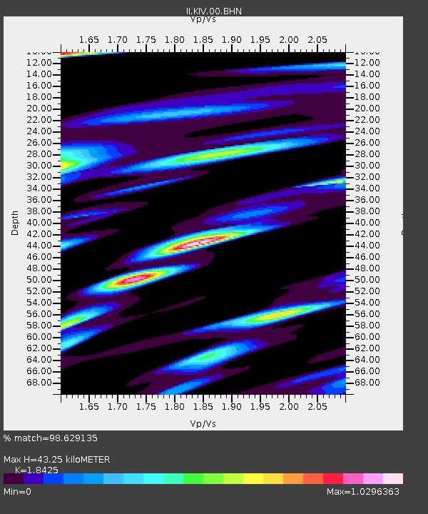
| Estimated Moho Depth: |
43.25 km |
| Estimated Crust Vp/Vs: |
1.84 |
| Assumed Crust Vp: |
6.247 km/s |
| Estimated Crust Vs: |
3.39 km/s |
| Estimated Crust Poisson's Ratio: |
0.29 |
|
| Radial Match: |
98.629135 % |
| Radial Bump: |
325 |
| Transverse Match: |
92.94812 % |
| Transverse Bump: |
400 |
| SOD ConfigId: |
61242 |
| Insert Time: |
2010-03-01 18:24:37.607 +0000 |
| GWidth: |
2.5 |
| Max Bumps: |
400 |
| Tol: |
0.001 |
|

Signal To Noise
| Channel | StoN | STA | LTA |
| II:KIV:00:BHN:19911222T08:53:55.390027Z | 4.5177183 | 9.533017E-7 | 2.1101397E-7 |
| II:KIV:00:BHE:19911222T08:53:55.390027Z | 4.7242017 | 7.6279787E-7 | 1.6146599E-7 |
| II:KIV:00:BHZ:19911222T08:53:55.390027Z | 8.1945095 | 1.9533074E-6 | 2.3836782E-7 |
| Arrivals |
| Ps | 6.0 SECOND |
| PpPs | 19 SECOND |
| PsPs/PpSs | 25 SECOND |


