You are here: Home > Network List > TA - USArray Transportable Network (new EarthScope stations) Stations List
> Station X43A Marvell, AR, USA > Earthquake Result Viewer
X43A Marvell, AR, USA - Earthquake Result Viewer
*The percent match for this event was below the threshold and hence no stack was calculated.
| Earthquake location: |
Colombia |
| Earthquake latitude/longitude: |
4.6/-76.6 |
| Earthquake time(UTC): |
2014/01/05 (005) 03:36:40 GMT |
| Earthquake Depth: |
54 km |
| Earthquake Magnitude: |
5.5 MWB, 5.6 MWC |
| Earthquake Catalog/Contributor: |
NEIC PDE/NEIC COMCAT |
|
| Network: |
TA USArray Transportable Network (new EarthScope stations) |
| Station: |
X43A Marvell, AR, USA |
| Lat/Lon: |
34.52 N/90.88 W |
| Elevation: |
53 m |
|
| Distance: |
32.6 deg |
| Az: |
337.862 deg |
| Baz: |
152.938 deg |
| Ray Param: |
$rayparam |
*The percent match for this event was below the threshold and hence was not used in the summary stack. |
|
| Radial Match: |
65.718666 % |
| Radial Bump: |
331 |
| Transverse Match: |
70.82419 % |
| Transverse Bump: |
287 |
| SOD ConfigId: |
626651 |
| Insert Time: |
2014-04-20 07:37:40.528 +0000 |
| GWidth: |
2.5 |
| Max Bumps: |
400 |
| Tol: |
0.001 |
|
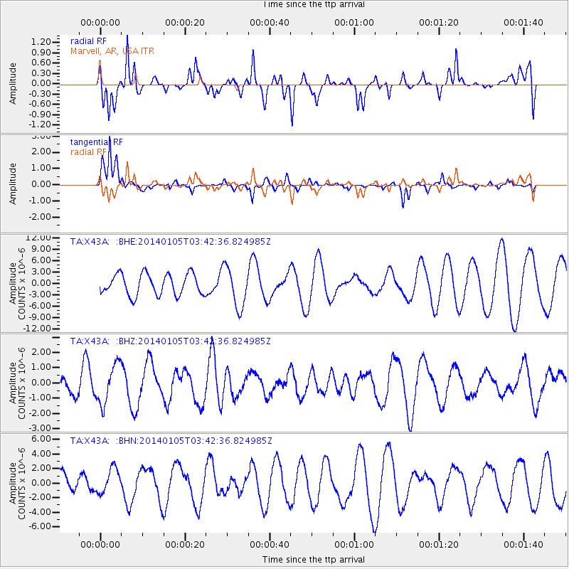
Signal To Noise
| Channel | StoN | STA | LTA |
| TA:X43A: :BHZ:20140105T03:42:36.824985Z | 1.372784 | 1.3149355E-6 | 9.578604E-7 |
| TA:X43A: :BHN:20140105T03:42:36.824985Z | 0.34633386 | 1.717543E-6 | 4.9592118E-6 |
| TA:X43A: :BHE:20140105T03:42:36.824985Z | 1.9625217 | 5.419927E-6 | 2.761716E-6 |
| Arrivals |
| Ps | |
| PpPs | |
| PsPs/PpSs | |


