You are here: Home > Network List > TA - USArray Transportable Network (new EarthScope stations) Stations List
> Station P50A Jamestown, OH, USA > Earthquake Result Viewer
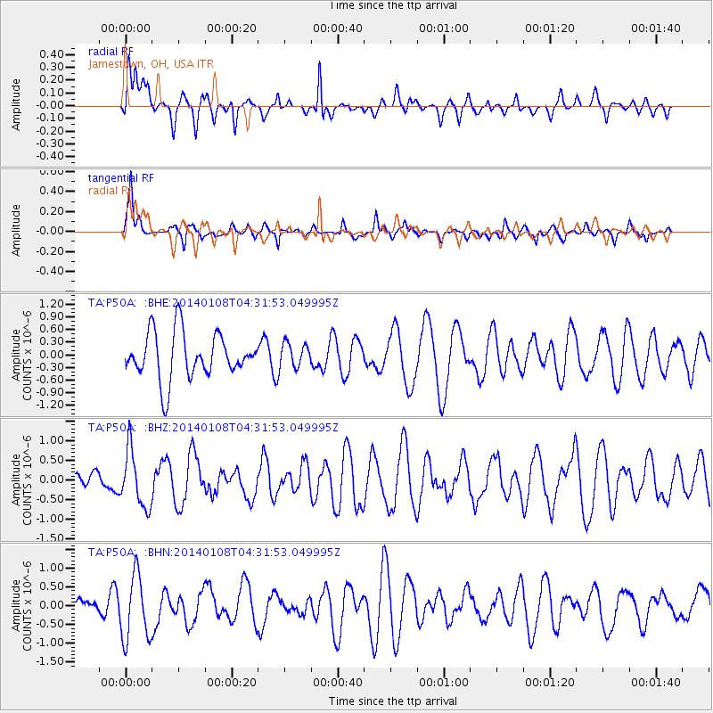
P50A Jamestown, OH, USA - Earthquake Result Viewer
*The percent match for this event was below the threshold and hence no stack was calculated.
| Earthquake location: |
Near Coast Of Northern Chile |
| Earthquake latitude/longitude: |
-20.7/-70.6 |
| Earthquake time(UTC): |
2014/01/08 (008) 04:22:10 GMT |
| Earthquake Depth: |
20 km |
| Earthquake Magnitude: |
5.7 MWW, 5.6 MWB, 5.6 MWR, 5.7 MWC |
| Earthquake Catalog/Contributor: |
NEIC PDE/NEIC COMCAT |
|
| Network: |
TA USArray Transportable Network (new EarthScope stations) |
| Station: |
P50A Jamestown, OH, USA |
| Lat/Lon: |
39.61 N/83.80 W |
| Elevation: |
318 m |
|
| Distance: |
61.3 deg |
| Az: |
348.427 deg |
| Baz: |
165.933 deg |
| Ray Param: |
$rayparam |
*The percent match for this event was below the threshold and hence was not used in the summary stack. |
|
| Radial Match: |
53.22523 % |
| Radial Bump: |
400 |
| Transverse Match: |
70.42873 % |
| Transverse Bump: |
342 |
| SOD ConfigId: |
626651 |
| Insert Time: |
2014-04-20 08:24:35.660 +0000 |
| GWidth: |
2.5 |
| Max Bumps: |
400 |
| Tol: |
0.001 |
|
Signal To Noise
| Channel | StoN | STA | LTA |
| TA:P50A: :BHZ:20140108T04:31:53.049995Z | 1.4698737 | 7.211862E-7 | 4.9064505E-7 |
| TA:P50A: :BHN:20140108T04:31:53.049995Z | 2.28726 | 8.821987E-7 | 3.8570113E-7 |
| TA:P50A: :BHE:20140108T04:31:53.049995Z | 0.50855243 | 2.7838794E-7 | 5.4741247E-7 |
| Arrivals |
| Ps | |
| PpPs | |
| PsPs/PpSs | |


