You are here: Home > Network List > PF - Volcanologic Network of Piton de Fournaise-OVPF Stations List
> Station GPS Grandes Pentes Sud > Earthquake Result Viewer
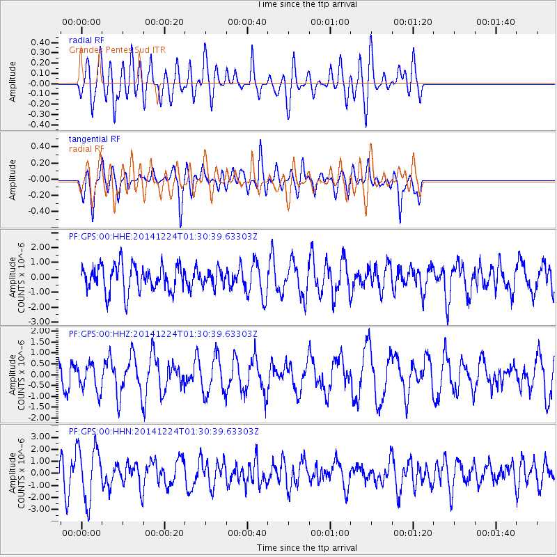
GPS Grandes Pentes Sud - Earthquake Result Viewer
*The percent match for this event was below the threshold and hence no stack was calculated.
| Earthquake location: |
West Of Macquarie Island |
| Earthquake latitude/longitude: |
-56.3/147.3 |
| Earthquake time(UTC): |
2014/12/24 (358) 01:19:38 GMT |
| Earthquake Depth: |
10 km |
| Earthquake Magnitude: |
5.5 MW, 5.2 mb, 5.2 Ms_20, 5.5 Mwb, 5.5 Mwc |
| Earthquake Catalog/Contributor: |
ISC/ISC |
|
| Network: |
PF Volcanologic Network of Piton de Fournaise-OVPF |
| Station: |
GPS Grandes Pentes Sud |
| Lat/Lon: |
21.27 S/55.76 E |
| Elevation: |
1004 m |
|
| Distance: |
73.4 deg |
| Az: |
256.653 deg |
| Baz: |
144.445 deg |
| Ray Param: |
$rayparam |
*The percent match for this event was below the threshold and hence was not used in the summary stack. |
|
| Radial Match: |
58.20345 % |
| Radial Bump: |
400 |
| Transverse Match: |
56.87659 % |
| Transverse Bump: |
400 |
| SOD ConfigId: |
3390531 |
| Insert Time: |
2019-04-15 18:27:31.186 +0000 |
| GWidth: |
2.5 |
| Max Bumps: |
400 |
| Tol: |
0.001 |
|
Signal To Noise
| Channel | StoN | STA | LTA |
| PF:GPS:00:HHZ:20141224T01:30:39.63303Z | 0.8643972 | 6.323538E-7 | 7.315547E-7 |
| PF:GPS:00:HHN:20141224T01:30:39.63303Z | 3.0900023 | 2.2611644E-6 | 7.317678E-7 |
| PF:GPS:00:HHE:20141224T01:30:39.63303Z | 0.602603 | 5.374496E-7 | 8.9188E-7 |
| Arrivals |
| Ps | |
| PpPs | |
| PsPs/PpSs | |


