You are here: Home > Network List > II - Global Seismograph Network (GSN - IRIS/IDA) Stations List
> Station KAPI Kappang, Sulawesi, Indonesia > Earthquake Result Viewer
KAPI Kappang, Sulawesi, Indonesia - Earthquake Result Viewer
| Earthquake location: |
Santa Cruz Islands |
| Earthquake latitude/longitude: |
-11.6/166.5 |
| Earthquake time(UTC): |
2014/01/09 (009) 06:39:33 GMT |
| Earthquake Depth: |
58 km |
| Earthquake Magnitude: |
5.8 MWW, 5.8 MWB, 5.9 MWC |
| Earthquake Catalog/Contributor: |
NEIC PDE/NEIC COMCAT |
|
| Network: |
II Global Seismograph Network (GSN - IRIS/IDA) |
| Station: |
KAPI Kappang, Sulawesi, Indonesia |
| Lat/Lon: |
5.01 S/119.75 E |
| Elevation: |
300 m |
|
| Distance: |
46.7 deg |
| Az: |
274.031 deg |
| Baz: |
101.142 deg |
| Ray Param: |
0.07031689 |
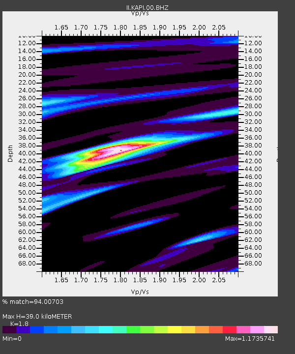
| Estimated Moho Depth: |
39.0 km |
| Estimated Crust Vp/Vs: |
1.80 |
| Assumed Crust Vp: |
6.343 km/s |
| Estimated Crust Vs: |
3.524 km/s |
| Estimated Crust Poisson's Ratio: |
0.28 |
|
| Radial Match: |
94.00703 % |
| Radial Bump: |
318 |
| Transverse Match: |
83.57187 % |
| Transverse Bump: |
400 |
| SOD ConfigId: |
626651 |
| Insert Time: |
2014-04-20 08:37:37.155 +0000 |
| GWidth: |
2.5 |
| Max Bumps: |
400 |
| Tol: |
0.001 |
|
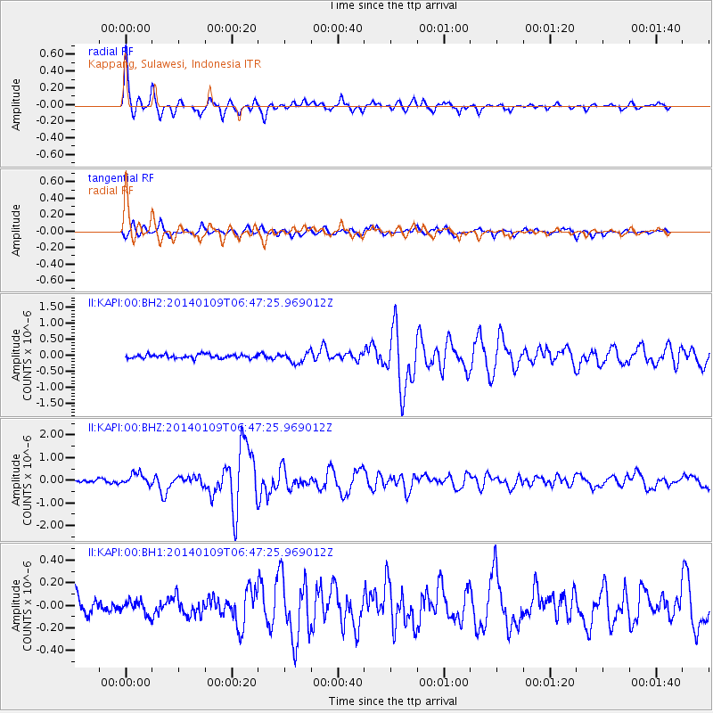
Signal To Noise
| Channel | StoN | STA | LTA |
| II:KAPI:00:BHZ:20140109T06:47:25.969012Z | 2.8558195 | 2.5487694E-7 | 8.924827E-8 |
| II:KAPI:00:BH1:20140109T06:47:25.969012Z | 0.70170325 | 6.1330596E-8 | 8.740247E-8 |
| II:KAPI:00:BH2:20140109T06:47:25.969012Z | 2.8541446 | 1.6930566E-7 | 5.9319227E-8 |
| Arrivals |
| Ps | 5.2 SECOND |
| PpPs | 16 SECOND |
| PsPs/PpSs | 21 SECOND |


