You are here: Home > Network List > US - United States National Seismic Network Stations List
> Station HAWA Hanford, Washington, USA > Earthquake Result Viewer
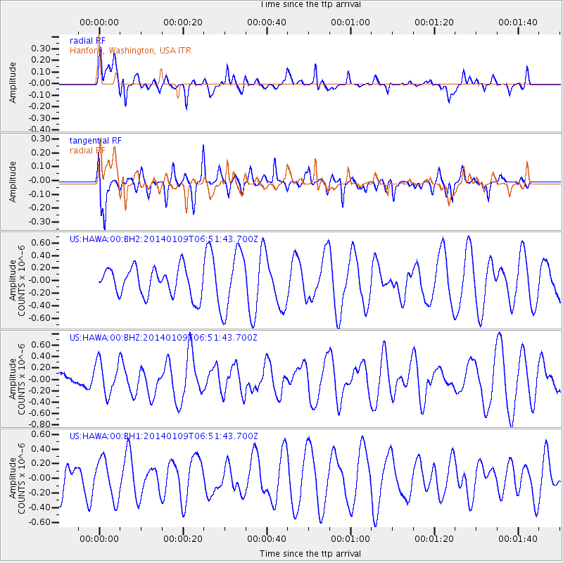
HAWA Hanford, Washington, USA - Earthquake Result Viewer
*The percent match for this event was below the threshold and hence no stack was calculated.
| Earthquake location: |
Santa Cruz Islands |
| Earthquake latitude/longitude: |
-11.6/166.5 |
| Earthquake time(UTC): |
2014/01/09 (009) 06:39:33 GMT |
| Earthquake Depth: |
58 km |
| Earthquake Magnitude: |
5.8 MWW, 5.8 MWB, 5.9 MWC |
| Earthquake Catalog/Contributor: |
NEIC PDE/NEIC COMCAT |
|
| Network: |
US United States National Seismic Network |
| Station: |
HAWA Hanford, Washington, USA |
| Lat/Lon: |
46.39 N/119.53 W |
| Elevation: |
364 m |
|
| Distance: |
87.5 deg |
| Az: |
41.741 deg |
| Baz: |
250.482 deg |
| Ray Param: |
$rayparam |
*The percent match for this event was below the threshold and hence was not used in the summary stack. |
|
| Radial Match: |
36.321407 % |
| Radial Bump: |
369 |
| Transverse Match: |
54.02033 % |
| Transverse Bump: |
395 |
| SOD ConfigId: |
626651 |
| Insert Time: |
2014-04-20 08:42:11.983 +0000 |
| GWidth: |
2.5 |
| Max Bumps: |
400 |
| Tol: |
0.001 |
|
Signal To Noise
| Channel | StoN | STA | LTA |
| US:HAWA:00:BHZ:20140109T06:51:43.700Z | 1.2288703 | 2.9864816E-7 | 2.430266E-7 |
| US:HAWA:00:BH1:20140109T06:51:43.700Z | 1.6623346 | 2.7412696E-7 | 1.6490482E-7 |
| US:HAWA:00:BH2:20140109T06:51:43.700Z | 2.1881557 | 4.8210103E-7 | 2.20323E-7 |
| Arrivals |
| Ps | |
| PpPs | |
| PsPs/PpSs | |


