You are here: Home > Network List > YT07 - POLENET Stations List
> Station UNGL UNGL > Earthquake Result Viewer
UNGL UNGL - Earthquake Result Viewer
| Earthquake location: |
West Of Macquarie Island |
| Earthquake latitude/longitude: |
-56.4/147.2 |
| Earthquake time(UTC): |
2014/12/24 (358) 01:58:02 GMT |
| Earthquake Depth: |
10 km |
| Earthquake Magnitude: |
5.5 MB |
| Earthquake Catalog/Contributor: |
NEIC PDE/NEIC COMCAT |
|
| Network: |
YT POLENET |
| Station: |
UNGL UNGL |
| Lat/Lon: |
79.77 S/82.52 W |
| Elevation: |
745 m |
|
| Distance: |
41.1 deg |
| Az: |
168.025 deg |
| Baz: |
220.231 deg |
| Ray Param: |
0.07400006 |
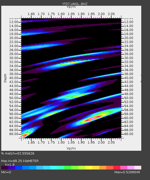
| Estimated Moho Depth: |
69.25 km |
| Estimated Crust Vp/Vs: |
1.60 |
| Assumed Crust Vp: |
6.182 km/s |
| Estimated Crust Vs: |
3.863 km/s |
| Estimated Crust Poisson's Ratio: |
0.18 |
|
| Radial Match: |
82.555626 % |
| Radial Bump: |
372 |
| Transverse Match: |
70.76372 % |
| Transverse Bump: |
400 |
| SOD ConfigId: |
3390531 |
| Insert Time: |
2019-04-15 18:30:43.395 +0000 |
| GWidth: |
2.5 |
| Max Bumps: |
400 |
| Tol: |
0.001 |
|

Signal To Noise
| Channel | StoN | STA | LTA |
| YT:UNGL: :BHZ:20141224T02:05:15.600013Z | 4.4528084 | 5.3135795E-7 | 1.1933098E-7 |
| YT:UNGL: :BHN:20141224T02:05:15.600013Z | 2.1599042 | 2.3387418E-7 | 1.0827988E-7 |
| YT:UNGL: :BHE:20141224T02:05:15.600013Z | 2.742562 | 2.2198192E-7 | 8.0939614E-8 |
| Arrivals |
| Ps | 7.2 SECOND |
| PpPs | 27 SECOND |
| PsPs/PpSs | 34 SECOND |


