You are here: Home > Network List > CI - Caltech Regional Seismic Network Stations List
> Station CIA CIA, Avalon Catalina Island, CA, USA > Earthquake Result Viewer
CIA CIA, Avalon Catalina Island, CA, USA - Earthquake Result Viewer
| Earthquake location: |
Kuril Islands |
| Earthquake latitude/longitude: |
44.3/148.4 |
| Earthquake time(UTC): |
2001/05/25 (145) 00:40:50 GMT |
| Earthquake Depth: |
33 km |
| Earthquake Magnitude: |
6.1 MB, 6.7 MS, 6.7 MW, 6.6 MW |
| Earthquake Catalog/Contributor: |
WHDF/NEIC |
|
| Network: |
CI Caltech Regional Seismic Network |
| Station: |
CIA CIA, Avalon Catalina Island, CA, USA |
| Lat/Lon: |
33.40 N/118.41 W |
| Elevation: |
467 m |
|
| Distance: |
69.7 deg |
| Az: |
62.973 deg |
| Baz: |
310.09 deg |
| Ray Param: |
0.05545204 |
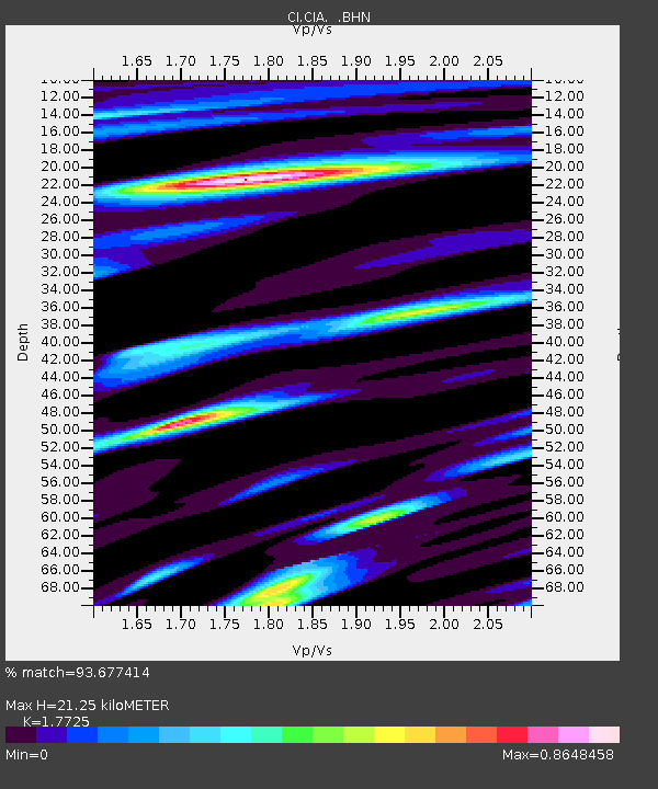
| Estimated Moho Depth: |
21.25 km |
| Estimated Crust Vp/Vs: |
1.77 |
| Assumed Crust Vp: |
6.048 km/s |
| Estimated Crust Vs: |
3.412 km/s |
| Estimated Crust Poisson's Ratio: |
0.27 |
|
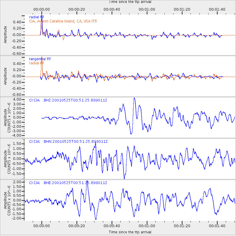
| Radial Match: |
93.677414 % |
| Radial Bump: |
369 |
| Transverse Match: |
75.19552 % |
| Transverse Bump: |
400 |
| SOD ConfigId: |
3770 |
| Insert Time: |
2010-02-25 20:55:20.049 +0000 |
| GWidth: |
2.5 |
| Max Bumps: |
400 |
| Tol: |
0.001 |
|
Signal To Noise
| Channel | StoN | STA | LTA |
| CI:CIA: :BHN:20010525T00:51:25.899011Z | 0.5787179 | 1.6061193E-7 | 2.775306E-7 |
| CI:CIA: :BHE:20010525T00:51:25.899011Z | 1.0139939 | 1.3245035E-7 | 1.3062244E-7 |
| CI:CIA: :BHZ:20010525T00:51:25.899011Z | 0.7780773 | 1.2909267E-7 | 1.6591238E-7 |
| Arrivals |
| Ps | 2.8 SECOND |
| PpPs | 9.4 SECOND |
| PsPs/PpSs | 12 SECOND |


