You are here: Home > Network List > US - United States National Seismic Network Stations List
> Station ELK Elko, Nevada, USA > Earthquake Result Viewer
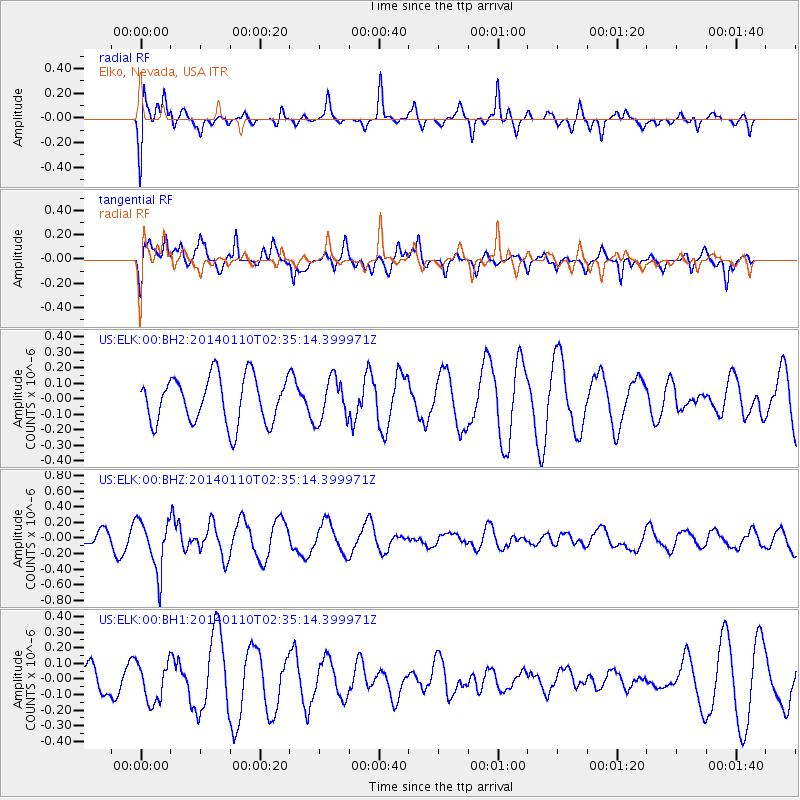
ELK Elko, Nevada, USA - Earthquake Result Viewer
*The percent match for this event was below the threshold and hence no stack was calculated.
| Earthquake location: |
Kermadec Islands Region |
| Earthquake latitude/longitude: |
-31.3/-179.6 |
| Earthquake time(UTC): |
2014/01/10 (010) 02:22:55 GMT |
| Earthquake Depth: |
211 km |
| Earthquake Magnitude: |
5.6 MWW, 5.7 MWB, 5.7 MWC |
| Earthquake Catalog/Contributor: |
NEIC PDE/NEIC COMCAT |
|
| Network: |
US United States National Seismic Network |
| Station: |
ELK Elko, Nevada, USA |
| Lat/Lon: |
40.74 N/115.24 W |
| Elevation: |
2210 m |
|
| Distance: |
93.1 deg |
| Az: |
43.302 deg |
| Baz: |
230.587 deg |
| Ray Param: |
$rayparam |
*The percent match for this event was below the threshold and hence was not used in the summary stack. |
|
| Radial Match: |
65.931335 % |
| Radial Bump: |
400 |
| Transverse Match: |
68.75711 % |
| Transverse Bump: |
400 |
| SOD ConfigId: |
626651 |
| Insert Time: |
2014-04-20 08:55:16.216 +0000 |
| GWidth: |
2.5 |
| Max Bumps: |
400 |
| Tol: |
0.001 |
|
Signal To Noise
| Channel | StoN | STA | LTA |
| US:ELK:00:BHZ:20140110T02:35:14.399971Z | 3.6784718 | 3.2580573E-7 | 8.857095E-8 |
| US:ELK:00:BH1:20140110T02:35:14.399971Z | 1.1224921 | 1.2478462E-7 | 1.1116749E-7 |
| US:ELK:00:BH2:20140110T02:35:14.399971Z | 0.9090173 | 1.3688428E-7 | 1.505849E-7 |
| Arrivals |
| Ps | |
| PpPs | |
| PsPs/PpSs | |


