You are here: Home > Network List > CI - Caltech Regional Seismic Network Stations List
> Station CIA CIA, Avalon Catalina Island, CA, USA > Earthquake Result Viewer
CIA CIA, Avalon Catalina Island, CA, USA - Earthquake Result Viewer
| Earthquake location: |
El Salvador |
| Earthquake latitude/longitude: |
13.0/-88.7 |
| Earthquake time(UTC): |
2001/01/13 (013) 17:33:32 GMT |
| Earthquake Depth: |
60 km |
| Earthquake Magnitude: |
6.4 MB, 7.8 MS, 7.7 MW, 7.5 ME |
| Earthquake Catalog/Contributor: |
WHDF/NEIC |
|
| Network: |
CI Caltech Regional Seismic Network |
| Station: |
CIA CIA, Avalon Catalina Island, CA, USA |
| Lat/Lon: |
33.40 N/118.41 W |
| Elevation: |
467 m |
|
| Distance: |
33.8 deg |
| Az: |
311.789 deg |
| Baz: |
119.704 deg |
| Ray Param: |
0.07788258 |
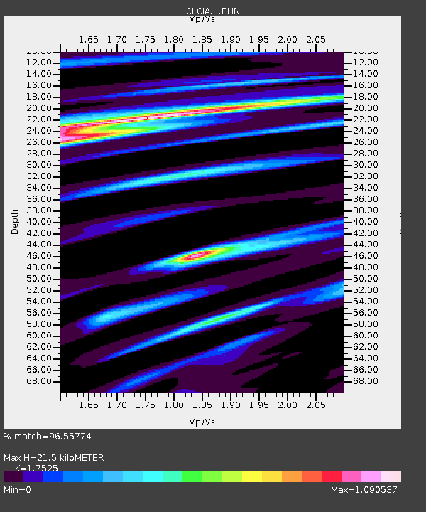
| Estimated Moho Depth: |
21.5 km |
| Estimated Crust Vp/Vs: |
1.75 |
| Assumed Crust Vp: |
6.048 km/s |
| Estimated Crust Vs: |
3.451 km/s |
| Estimated Crust Poisson's Ratio: |
0.26 |
|
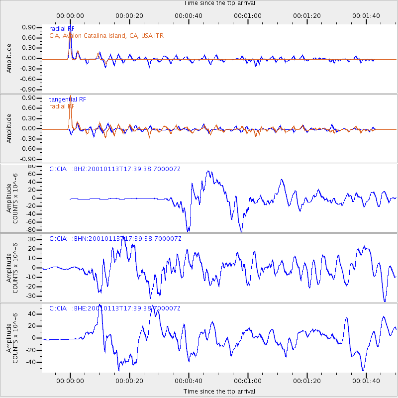
| Radial Match: |
96.55774 % |
| Radial Bump: |
335 |
| Transverse Match: |
86.39147 % |
| Transverse Bump: |
400 |
| SOD ConfigId: |
3787 |
| Insert Time: |
2010-02-25 20:55:21.168 +0000 |
| GWidth: |
2.5 |
| Max Bumps: |
400 |
| Tol: |
0.001 |
|
Signal To Noise
| Channel | StoN | STA | LTA |
| CI:CIA: :BHN:20010113T17:39:38.700007Z | 1.9267012 | 1.5016319E-6 | 7.793797E-7 |
| CI:CIA: :BHE:20010113T17:39:38.700007Z | 2.0683467 | 1.3663177E-6 | 6.605845E-7 |
| CI:CIA: :BHZ:20010113T17:39:38.700007Z | 3.589797 | 2.7820147E-6 | 7.749783E-7 |
| Arrivals |
| Ps | 2.9 SECOND |
| PpPs | 9.1 SECOND |
| PsPs/PpSs | 12 SECOND |


