You are here: Home > Network List > CN - Canadian National Seismograph Network Stations List
> Station INK INUVIK, NT > Earthquake Result Viewer
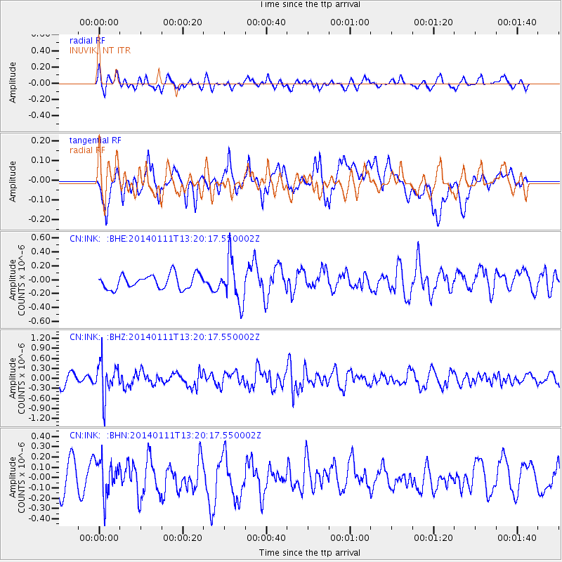
INK INUVIK, NT - Earthquake Result Viewer
*The percent match for this event was below the threshold and hence no stack was calculated.
| Earthquake location: |
Near Coast Of Chiapas, Mexico |
| Earthquake latitude/longitude: |
14.6/-92.1 |
| Earthquake time(UTC): |
2014/01/11 (011) 13:10:51 GMT |
| Earthquake Depth: |
78 km |
| Earthquake Magnitude: |
5.5 MWB, 5.7 MWC |
| Earthquake Catalog/Contributor: |
NEIC PDE/NEIC COMCAT |
|
| Network: |
CN Canadian National Seismograph Network |
| Station: |
INK INUVIK, NT |
| Lat/Lon: |
68.31 N/133.53 W |
| Elevation: |
44 m |
|
| Distance: |
59.8 deg |
| Az: |
343.452 deg |
| Baz: |
132.139 deg |
| Ray Param: |
$rayparam |
*The percent match for this event was below the threshold and hence was not used in the summary stack. |
|
| Radial Match: |
58.79859 % |
| Radial Bump: |
400 |
| Transverse Match: |
65.472435 % |
| Transverse Bump: |
400 |
| SOD ConfigId: |
626651 |
| Insert Time: |
2014-04-20 09:03:11.580 +0000 |
| GWidth: |
2.5 |
| Max Bumps: |
400 |
| Tol: |
0.001 |
|
Signal To Noise
| Channel | StoN | STA | LTA |
| CN:INK: :BHZ:20140111T13:20:17.550002Z | 2.0107024 | 5.234068E-7 | 2.6031043E-7 |
| CN:INK: :BHN:20140111T13:20:17.550002Z | 1.2962952 | 1.826417E-7 | 1.4089515E-7 |
| CN:INK: :BHE:20140111T13:20:17.550002Z | 3.0909011 | 3.1653917E-7 | 1.0241E-7 |
| Arrivals |
| Ps | |
| PpPs | |
| PsPs/PpSs | |


