You are here: Home > Network List > TA - USArray Transportable Network (new EarthScope stations) Stations List
> Station G65A Princeton, ME, USA > Earthquake Result Viewer
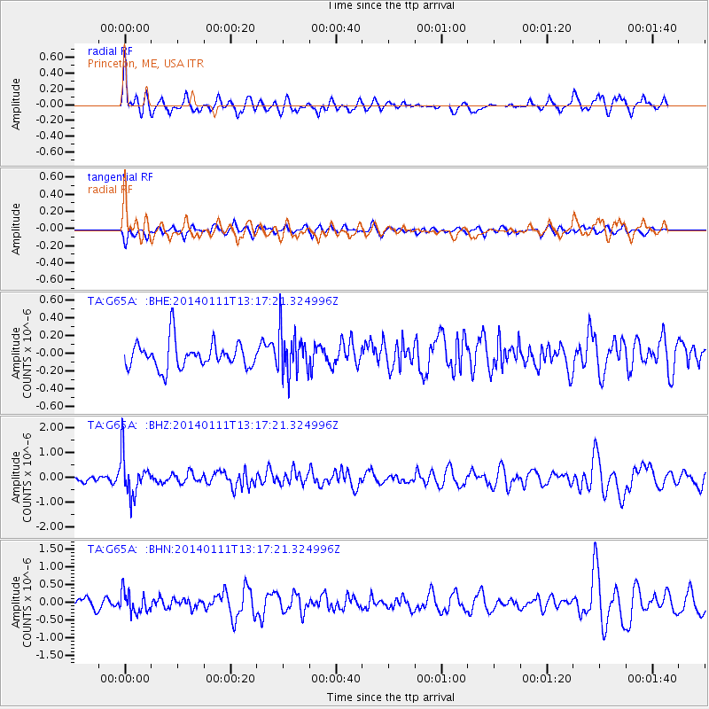
G65A Princeton, ME, USA - Earthquake Result Viewer
*The percent match for this event was below the threshold and hence no stack was calculated.
| Earthquake location: |
Near Coast Of Chiapas, Mexico |
| Earthquake latitude/longitude: |
14.6/-92.1 |
| Earthquake time(UTC): |
2014/01/11 (011) 13:10:51 GMT |
| Earthquake Depth: |
78 km |
| Earthquake Magnitude: |
5.5 MWB, 5.7 MWC |
| Earthquake Catalog/Contributor: |
NEIC PDE/NEIC COMCAT |
|
| Network: |
TA USArray Transportable Network (new EarthScope stations) |
| Station: |
G65A Princeton, ME, USA |
| Lat/Lon: |
45.20 N/67.56 W |
| Elevation: |
78 m |
|
| Distance: |
36.8 deg |
| Az: |
29.276 deg |
| Baz: |
222.028 deg |
| Ray Param: |
$rayparam |
*The percent match for this event was below the threshold and hence was not used in the summary stack. |
|
| Radial Match: |
65.812775 % |
| Radial Bump: |
400 |
| Transverse Match: |
43.964447 % |
| Transverse Bump: |
400 |
| SOD ConfigId: |
626651 |
| Insert Time: |
2014-04-20 09:12:51.520 +0000 |
| GWidth: |
2.5 |
| Max Bumps: |
400 |
| Tol: |
0.001 |
|
Signal To Noise
| Channel | StoN | STA | LTA |
| TA:G65A: :BHZ:20140111T13:17:21.324996Z | 4.810595 | 8.123705E-7 | 1.6887111E-7 |
| TA:G65A: :BHN:20140111T13:17:21.324996Z | 1.8028066 | 3.0100364E-7 | 1.669639E-7 |
| TA:G65A: :BHE:20140111T13:17:21.324996Z | 1.6502615 | 2.4046784E-7 | 1.4571498E-7 |
| Arrivals |
| Ps | |
| PpPs | |
| PsPs/PpSs | |


