You are here: Home > Network List > KN - Kyrgyz Seismic Telemetry Network Stations List
> Station TKM2 - > Earthquake Result Viewer
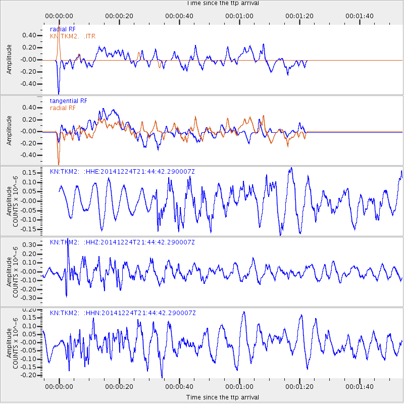
TKM2 - - Earthquake Result Viewer
*The percent match for this event was below the threshold and hence no stack was calculated.
| Earthquake location: |
Tanimbar Islands Reg., Indonesia |
| Earthquake latitude/longitude: |
-6.2/131.1 |
| Earthquake time(UTC): |
2014/12/24 (358) 21:34:05 GMT |
| Earthquake Depth: |
49 km |
| Earthquake Magnitude: |
5.1 MW, 5.2 mb |
| Earthquake Catalog/Contributor: |
ISC/ISC |
|
| Network: |
KN Kyrgyz Seismic Telemetry Network |
| Station: |
TKM2 - |
| Lat/Lon: |
42.92 N/75.60 E |
| Elevation: |
2020 m |
|
| Distance: |
70.1 deg |
| Az: |
319.903 deg |
| Baz: |
119.341 deg |
| Ray Param: |
$rayparam |
*The percent match for this event was below the threshold and hence was not used in the summary stack. |
|
| Radial Match: |
47.675903 % |
| Radial Bump: |
400 |
| Transverse Match: |
42.37942 % |
| Transverse Bump: |
400 |
| SOD ConfigId: |
3390531 |
| Insert Time: |
2019-04-15 18:41:21.801 +0000 |
| GWidth: |
2.5 |
| Max Bumps: |
400 |
| Tol: |
0.001 |
|
Signal To Noise
| Channel | StoN | STA | LTA |
| KN:TKM2: :HHZ:20141224T21:44:42.290007Z | 1.8851546 | 1.1744441E-7 | 6.229961E-8 |
| KN:TKM2: :HHN:20141224T21:44:42.290007Z | 1.0643567 | 7.967437E-8 | 7.485684E-8 |
| KN:TKM2: :HHE:20141224T21:44:42.290007Z | 0.9101504 | 6.133816E-8 | 6.739344E-8 |
| Arrivals |
| Ps | |
| PpPs | |
| PsPs/PpSs | |


