You are here: Home > Network List > TA - USArray Transportable Network (new EarthScope stations) Stations List
> Station J62A Henniker, NH, USA > Earthquake Result Viewer
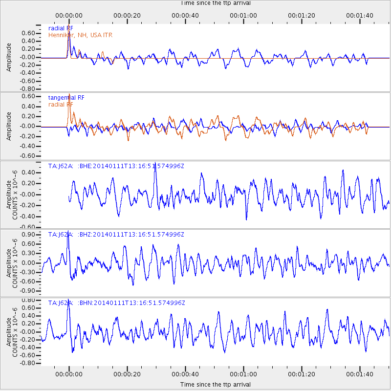
J62A Henniker, NH, USA - Earthquake Result Viewer
*The percent match for this event was below the threshold and hence no stack was calculated.
| Earthquake location: |
Near Coast Of Chiapas, Mexico |
| Earthquake latitude/longitude: |
14.6/-92.1 |
| Earthquake time(UTC): |
2014/01/11 (011) 13:10:51 GMT |
| Earthquake Depth: |
78 km |
| Earthquake Magnitude: |
5.5 MWB, 5.7 MWC |
| Earthquake Catalog/Contributor: |
NEIC PDE/NEIC COMCAT |
|
| Network: |
TA USArray Transportable Network (new EarthScope stations) |
| Station: |
J62A Henniker, NH, USA |
| Lat/Lon: |
43.23 N/71.81 W |
| Elevation: |
266 m |
|
| Distance: |
33.4 deg |
| Az: |
27.387 deg |
| Baz: |
217.527 deg |
| Ray Param: |
$rayparam |
*The percent match for this event was below the threshold and hence was not used in the summary stack. |
|
| Radial Match: |
63.36902 % |
| Radial Bump: |
400 |
| Transverse Match: |
54.3319 % |
| Transverse Bump: |
400 |
| SOD ConfigId: |
626651 |
| Insert Time: |
2014-04-20 09:14:39.693 +0000 |
| GWidth: |
2.5 |
| Max Bumps: |
400 |
| Tol: |
0.001 |
|
Signal To Noise
| Channel | StoN | STA | LTA |
| TA:J62A: :BHZ:20140111T13:16:51.574996Z | 2.579829 | 4.0423654E-7 | 1.5669121E-7 |
| TA:J62A: :BHN:20140111T13:16:51.574996Z | 2.0728533 | 3.5832014E-7 | 1.7286324E-7 |
| TA:J62A: :BHE:20140111T13:16:51.574996Z | 1.4723836 | 2.207747E-7 | 1.4994373E-7 |
| Arrivals |
| Ps | |
| PpPs | |
| PsPs/PpSs | |


