You are here: Home > Network List > TA - USArray Transportable Network (new EarthScope stations) Stations List
> Station MDND Maddock, ND, USA > Earthquake Result Viewer
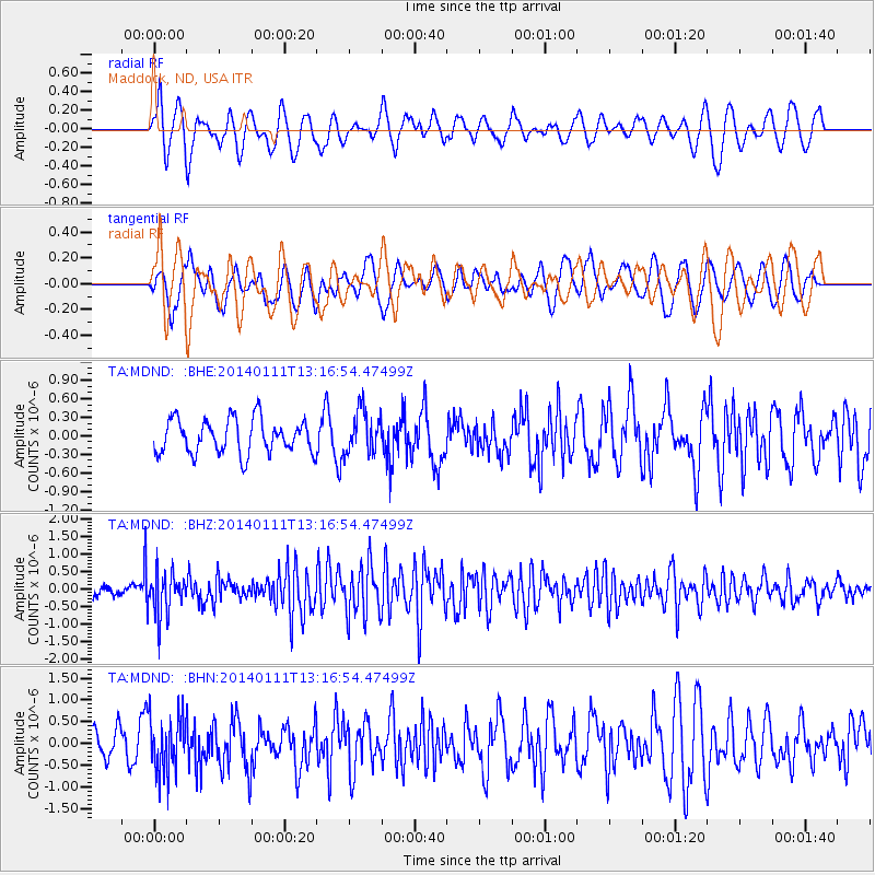
MDND Maddock, ND, USA - Earthquake Result Viewer
*The percent match for this event was below the threshold and hence no stack was calculated.
| Earthquake location: |
Near Coast Of Chiapas, Mexico |
| Earthquake latitude/longitude: |
14.6/-92.1 |
| Earthquake time(UTC): |
2014/01/11 (011) 13:10:51 GMT |
| Earthquake Depth: |
78 km |
| Earthquake Magnitude: |
5.5 MWB, 5.7 MWC |
| Earthquake Catalog/Contributor: |
NEIC PDE/NEIC COMCAT |
|
| Network: |
TA USArray Transportable Network (new EarthScope stations) |
| Station: |
MDND Maddock, ND, USA |
| Lat/Lon: |
47.85 N/99.60 W |
| Elevation: |
479 m |
|
| Distance: |
33.7 deg |
| Az: |
350.828 deg |
| Baz: |
166.758 deg |
| Ray Param: |
$rayparam |
*The percent match for this event was below the threshold and hence was not used in the summary stack. |
|
| Radial Match: |
53.94136 % |
| Radial Bump: |
400 |
| Transverse Match: |
51.212574 % |
| Transverse Bump: |
400 |
| SOD ConfigId: |
626651 |
| Insert Time: |
2014-04-20 09:16:07.345 +0000 |
| GWidth: |
2.5 |
| Max Bumps: |
400 |
| Tol: |
0.001 |
|
Signal To Noise
| Channel | StoN | STA | LTA |
| TA:MDND: :BHZ:20140111T13:16:54.47499Z | 4.192152 | 6.0048296E-7 | 1.4323979E-7 |
| TA:MDND: :BHN:20140111T13:16:54.47499Z | 2.2019367 | 6.4760434E-7 | 2.941067E-7 |
| TA:MDND: :BHE:20140111T13:16:54.47499Z | 1.2582178 | 3.4920413E-7 | 2.775387E-7 |
| Arrivals |
| Ps | |
| PpPs | |
| PsPs/PpSs | |


