You are here: Home > Network List > TA - USArray Transportable Network (new EarthScope stations) Stations List
> Station POKR Poker Plat Research Range, AK, USA > Earthquake Result Viewer
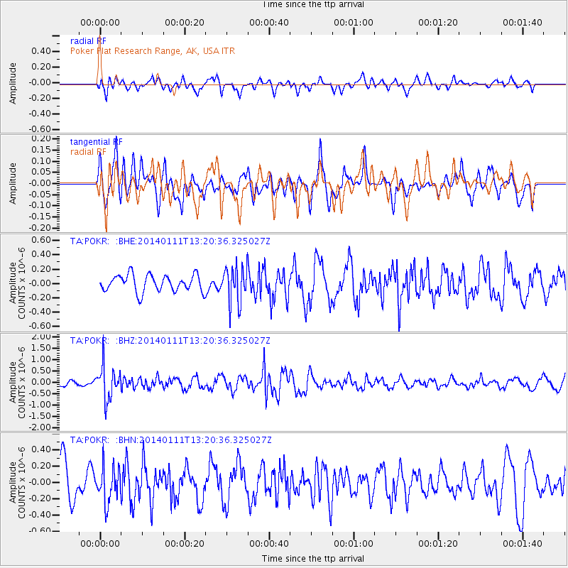
POKR Poker Plat Research Range, AK, USA - Earthquake Result Viewer
*The percent match for this event was below the threshold and hence no stack was calculated.
| Earthquake location: |
Near Coast Of Chiapas, Mexico |
| Earthquake latitude/longitude: |
14.6/-92.1 |
| Earthquake time(UTC): |
2014/01/11 (011) 13:10:51 GMT |
| Earthquake Depth: |
78 km |
| Earthquake Magnitude: |
5.5 MWB, 5.7 MWC |
| Earthquake Catalog/Contributor: |
NEIC PDE/NEIC COMCAT |
|
| Network: |
TA USArray Transportable Network (new EarthScope stations) |
| Station: |
POKR Poker Plat Research Range, AK, USA |
| Lat/Lon: |
65.12 N/147.43 W |
| Elevation: |
501 m |
|
| Distance: |
62.6 deg |
| Az: |
336.91 deg |
| Baz: |
116.207 deg |
| Ray Param: |
$rayparam |
*The percent match for this event was below the threshold and hence was not used in the summary stack. |
|
| Radial Match: |
49.192734 % |
| Radial Bump: |
400 |
| Transverse Match: |
59.631775 % |
| Transverse Bump: |
400 |
| SOD ConfigId: |
626651 |
| Insert Time: |
2014-04-20 09:16:20.865 +0000 |
| GWidth: |
2.5 |
| Max Bumps: |
400 |
| Tol: |
0.001 |
|
Signal To Noise
| Channel | StoN | STA | LTA |
| TA:POKR: :BHZ:20140111T13:20:36.325027Z | 3.3047771 | 7.31659E-7 | 2.2139434E-7 |
| TA:POKR: :BHN:20140111T13:20:36.325027Z | 0.8185249 | 2.1651825E-7 | 2.6452247E-7 |
| TA:POKR: :BHE:20140111T13:20:36.325027Z | 2.1719189 | 2.5346623E-7 | 1.1670152E-7 |
| Arrivals |
| Ps | |
| PpPs | |
| PsPs/PpSs | |


