You are here: Home > Network List > TA - USArray Transportable Network (new EarthScope stations) Stations List
> Station O48A Farmland, IN, USA > Earthquake Result Viewer
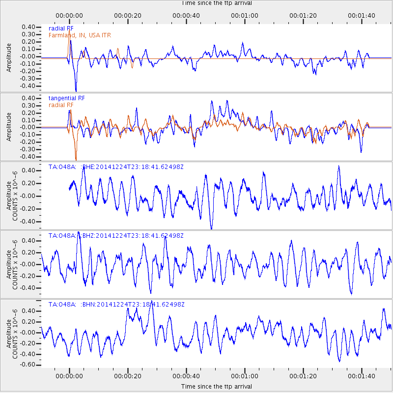
O48A Farmland, IN, USA - Earthquake Result Viewer
*The percent match for this event was below the threshold and hence no stack was calculated.
| Earthquake location: |
Near East Coast Of Honshu, Japan |
| Earthquake latitude/longitude: |
37.2/141.5 |
| Earthquake time(UTC): |
2014/12/24 (358) 23:06:05 GMT |
| Earthquake Depth: |
10 km |
| Earthquake Magnitude: |
5.5 MB |
| Earthquake Catalog/Contributor: |
NEIC PDE/NEIC COMCAT |
|
| Network: |
TA USArray Transportable Network (new EarthScope stations) |
| Station: |
O48A Farmland, IN, USA |
| Lat/Lon: |
40.26 N/85.16 W |
| Elevation: |
300 m |
|
| Distance: |
91.8 deg |
| Az: |
33.851 deg |
| Baz: |
324.479 deg |
| Ray Param: |
$rayparam |
*The percent match for this event was below the threshold and hence was not used in the summary stack. |
|
| Radial Match: |
45.7485 % |
| Radial Bump: |
400 |
| Transverse Match: |
34.072186 % |
| Transverse Bump: |
400 |
| SOD ConfigId: |
3390531 |
| Insert Time: |
2019-04-15 18:48:56.142 +0000 |
| GWidth: |
2.5 |
| Max Bumps: |
400 |
| Tol: |
0.001 |
|
Signal To Noise
| Channel | StoN | STA | LTA |
| TA:O48A: :BHZ:20141224T23:18:41.62498Z | 1.3021926 | 2.4803916E-7 | 1.9047809E-7 |
| TA:O48A: :BHN:20141224T23:18:41.62498Z | 2.2714994 | 3.926131E-7 | 1.7284313E-7 |
| TA:O48A: :BHE:20141224T23:18:41.62498Z | 0.9842829 | 1.6482922E-7 | 1.6746122E-7 |
| Arrivals |
| Ps | |
| PpPs | |
| PsPs/PpSs | |


