You are here: Home > Network List > US - United States National Seismic Network Stations List
> Station MIAR Mount Ida, Arkansas, USA > Earthquake Result Viewer
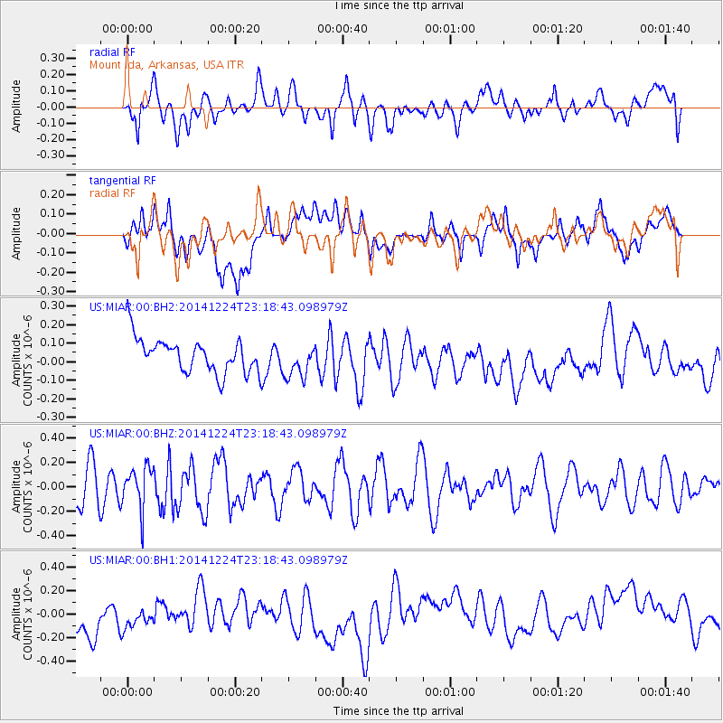
MIAR Mount Ida, Arkansas, USA - Earthquake Result Viewer
*The percent match for this event was below the threshold and hence no stack was calculated.
| Earthquake location: |
Near East Coast Of Honshu, Japan |
| Earthquake latitude/longitude: |
37.2/141.5 |
| Earthquake time(UTC): |
2014/12/24 (358) 23:06:05 GMT |
| Earthquake Depth: |
10 km |
| Earthquake Magnitude: |
5.5 MB |
| Earthquake Catalog/Contributor: |
NEIC PDE/NEIC COMCAT |
|
| Network: |
US United States National Seismic Network |
| Station: |
MIAR Mount Ida, Arkansas, USA |
| Lat/Lon: |
34.55 N/93.58 W |
| Elevation: |
207 m |
|
| Distance: |
92.1 deg |
| Az: |
42.645 deg |
| Baz: |
319.072 deg |
| Ray Param: |
$rayparam |
*The percent match for this event was below the threshold and hence was not used in the summary stack. |
|
| Radial Match: |
48.856457 % |
| Radial Bump: |
400 |
| Transverse Match: |
23.55379 % |
| Transverse Bump: |
400 |
| SOD ConfigId: |
3390531 |
| Insert Time: |
2019-04-15 18:49:32.198 +0000 |
| GWidth: |
2.5 |
| Max Bumps: |
400 |
| Tol: |
0.001 |
|
Signal To Noise
| Channel | StoN | STA | LTA |
| US:MIAR:00:BHZ:20141224T23:18:43.098979Z | 1.1805484 | 1.7061187E-7 | 1.4451916E-7 |
| US:MIAR:00:BH1:20141224T23:18:43.098979Z | 0.7351804 | 1.073648E-7 | 1.4603872E-7 |
| US:MIAR:00:BH2:20141224T23:18:43.098979Z | 1.0220969 | 9.2504536E-8 | 9.050467E-8 |
| Arrivals |
| Ps | |
| PpPs | |
| PsPs/PpSs | |


