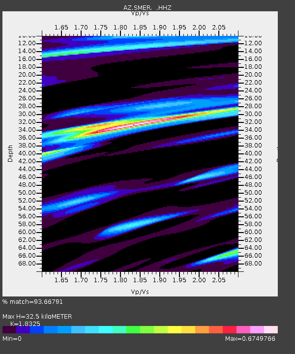
SMER AZ.SMER - Earthquake Result Viewer
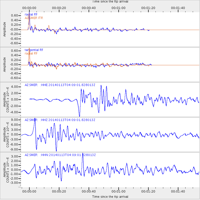
Earthquake location: Puerto Rico Region
Earthquake latitude/longitude: 19.0/-66.8
Earthquake time(UTC): 2014/01/13 (013) 04:01:03 GMT
Earthquake Depth: 20 km
Earthquake Magnitude: 6.4 MWW, 6.2 MWB, 6.3 MWC, 6.4 MI, 6.4 MWC
Earthquake Catalog/Contributor: NEIC PDE/NEIC COMCAT
Network: AZ ANZA Regional Network
Station: SMER AZ.SMER
Lat/Lon: 33.46 N/117.17 W
Elevation: 355 m
Distance: 47.0 deg
Az: 298.264 deg
Baz: 94.71 deg
Ray Param: 0.07027873
Estimated Moho Depth: 32.5 km
Estimated Crust Vp/Vs: 1.83
Assumed Crust Vp: 6.264 km/s
Estimated Crust Vs: 3.418 km/s
Estimated Crust Poisson's Ratio: 0.29
Radial Match: 93.66791 %
Radial Bump: 238
Transverse Match: 78.8031 %
Transverse Bump: 400
SOD ConfigId: 626651
Insert Time: 2014-04-20 09:24:25.606 +0000
GWidth: 2.5
Max Bumps: 400
Tol: 0.001

Signal To Noise

ChannelStoNSTALTA
AZ:SMER: :HHZ:20140113T04:09:01.828013Z25.836934.172457E-61.61492E-7
AZ:SMER: :HHN:20140113T04:09:01.828013Z2.19109157.925526E-73.6171588E-7
AZ:SMER: :HHE:20140113T04:09:01.828013Z8.8656572.0584412E-62.3218146E-7
Arrivals
Ps4.6 SECOND
PpPs14 SECOND
PsPs/PpSs18 SECOND