You are here: Home > Network List > GH - Ghana Digital Seismic Network Stations List
> Station KLEF Ho, Ghana > Earthquake Result Viewer
KLEF Ho, Ghana - Earthquake Result Viewer
| Earthquake location: |
Puerto Rico Region |
| Earthquake latitude/longitude: |
19.0/-66.8 |
| Earthquake time(UTC): |
2014/01/13 (013) 04:01:03 GMT |
| Earthquake Depth: |
20 km |
| Earthquake Magnitude: |
6.4 MWW, 6.2 MWB, 6.3 MWC, 6.4 MI, 6.4 MWC |
| Earthquake Catalog/Contributor: |
NEIC PDE/NEIC COMCAT |
|
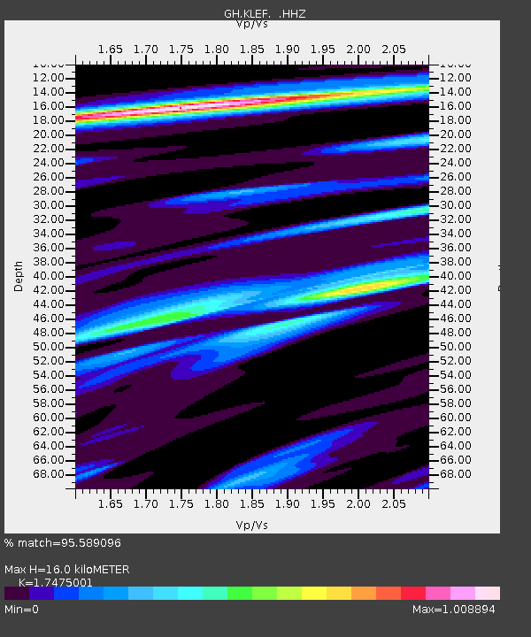
| Network: |
GH Ghana Digital Seismic Network |
| Station: |
KLEF Ho, Ghana |
| Lat/Lon: |
6.61 N/0.44 E |
| Elevation: |
313 m |
|
| Distance: |
66.4 deg |
| Az: |
91.023 deg |
| Baz: |
287.815 deg |
| Ray Param: |
0.057626892 |
| Estimated Moho Depth: |
16.0 km |
| Estimated Crust Vp/Vs: |
1.75 |
| Assumed Crust Vp: |
6.612 km/s |
| Estimated Crust Vs: |
3.784 km/s |
| Estimated Crust Poisson's Ratio: |
0.26 |
|
| Radial Match: |
95.589096 % |
| Radial Bump: |
331 |
| Transverse Match: |
75.52107 % |
| Transverse Bump: |
400 |
| SOD ConfigId: |
626651 |
| Insert Time: |
2014-04-20 09:29:44.570 +0000 |
| GWidth: |
2.5 |
| Max Bumps: |
400 |
| Tol: |
0.001 |
|

Signal To Noise
| Channel | StoN | STA | LTA |
| GH:KLEF: :HHZ:20140113T04:11:19.589976Z | 13.018375 | 1.3233541E-6 | 1.0165278E-7 |
| GH:KLEF: :HHN:20140113T04:11:19.589976Z | 3.2796016 | 2.6097123E-7 | 7.957406E-8 |
| GH:KLEF: :HHE:20140113T04:11:19.589976Z | 6.303745 | 6.9966904E-7 | 1.109926E-7 |
| Arrivals |
| Ps | 1.9 SECOND |
| PpPs | 6.4 SECOND |
| PsPs/PpSs | 8.3 SECOND |


