You are here: Home > Network List > GH - Ghana Digital Seismic Network Stations List
> Station KUKU Kukurantumi, Ghana > Earthquake Result Viewer
KUKU Kukurantumi, Ghana - Earthquake Result Viewer
| Earthquake location: |
Puerto Rico Region |
| Earthquake latitude/longitude: |
19.0/-66.8 |
| Earthquake time(UTC): |
2014/01/13 (013) 04:01:03 GMT |
| Earthquake Depth: |
20 km |
| Earthquake Magnitude: |
6.4 MWW, 6.2 MWB, 6.3 MWC, 6.4 MI, 6.4 MWC |
| Earthquake Catalog/Contributor: |
NEIC PDE/NEIC COMCAT |
|
| Network: |
GH Ghana Digital Seismic Network |
| Station: |
KUKU Kukurantumi, Ghana |
| Lat/Lon: |
6.19 N/0.37 W |
| Elevation: |
240 m |
|
| Distance: |
65.8 deg |
| Az: |
91.73 deg |
| Baz: |
288.012 deg |
| Ray Param: |
0.058043536 |
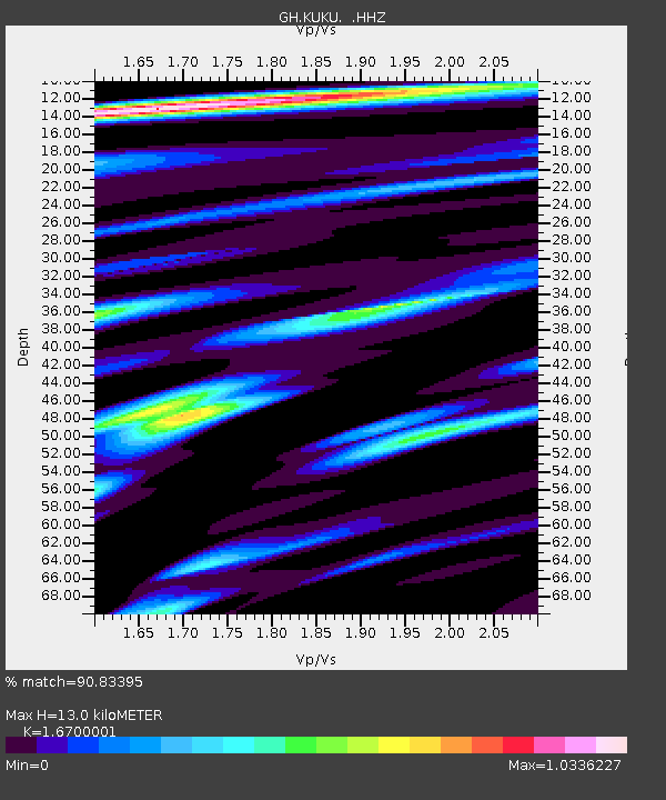
| Estimated Moho Depth: |
13.0 km |
| Estimated Crust Vp/Vs: |
1.67 |
| Assumed Crust Vp: |
6.419 km/s |
| Estimated Crust Vs: |
3.844 km/s |
| Estimated Crust Poisson's Ratio: |
0.22 |
|
| Radial Match: |
90.83395 % |
| Radial Bump: |
400 |
| Transverse Match: |
73.92903 % |
| Transverse Bump: |
400 |
| SOD ConfigId: |
626651 |
| Insert Time: |
2014-04-20 09:29:46.952 +0000 |
| GWidth: |
2.5 |
| Max Bumps: |
400 |
| Tol: |
0.001 |
|

Signal To Noise
| Channel | StoN | STA | LTA |
| GH:KUKU: :HHZ:20140113T04:11:15.520029Z | 9.797454 | 1.2304552E-6 | 1.2558927E-7 |
| GH:KUKU: :HHN:20140113T04:11:15.520029Z | 3.4505925 | 2.6415378E-7 | 7.6553164E-8 |
| GH:KUKU: :HHE:20140113T04:11:15.520029Z | 3.6677098 | 4.4111135E-7 | 1.2026888E-7 |
| Arrivals |
| Ps | 1.4 SECOND |
| PpPs | 5.2 SECOND |
| PsPs/PpSs | 6.6 SECOND |


