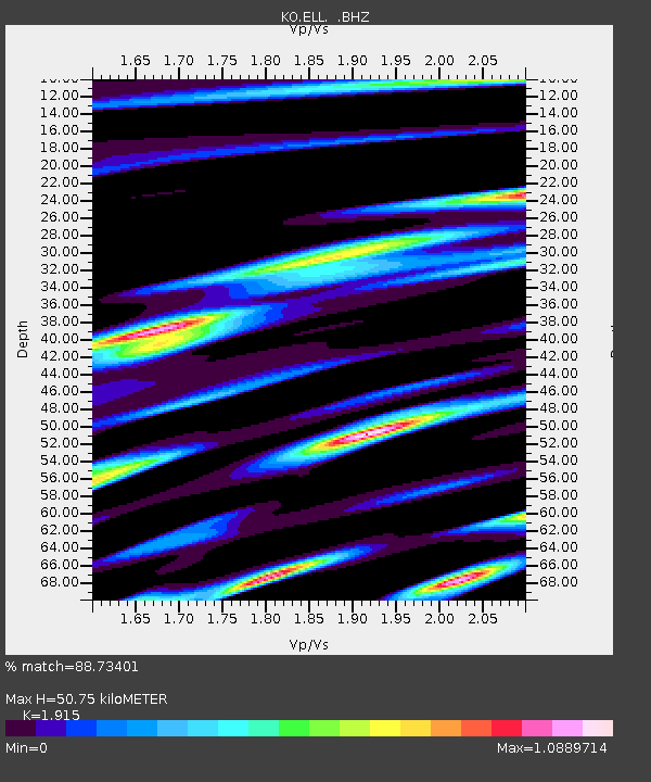
ELL Elmali-Antalya-Turkey - Earthquake Result Viewer

Earthquake location: Puerto Rico Region
Earthquake latitude/longitude: 19.0/-66.8
Earthquake time(UTC): 2014/01/13 (013) 04:01:03 GMT
Earthquake Depth: 20 km
Earthquake Magnitude: 6.4 MWW, 6.2 MWB, 6.3 MWC, 6.4 MI, 6.4 MWC
Earthquake Catalog/Contributor: NEIC PDE/NEIC COMCAT
Network: KO Kandilli Observatory Digital Broadband Seismic Network
Station: ELL Elmali-Antalya-Turkey
Lat/Lon: 36.75 N/29.91 E
Elevation: 1230 m
Distance: 84.0 deg
Az: 53.327 deg
Baz: 289.16 deg
Ray Param: 0.04576253
Estimated Moho Depth: 50.75 km
Estimated Crust Vp/Vs: 1.91
Assumed Crust Vp: 6.12 km/s
Estimated Crust Vs: 3.196 km/s
Estimated Crust Poisson's Ratio: 0.31
Radial Match: 88.73401 %
Radial Bump: 400
Transverse Match: 86.01731 %
Transverse Bump: 400
SOD ConfigId: 626651
Insert Time: 2014-04-20 09:32:45.337 +0000
GWidth: 2.5
Max Bumps: 400
Tol: 0.001

Signal To Noise

ChannelStoNSTALTA
KO:ELL: :BHZ:20140113T04:13:00.71998Z7.31725841.7126083E-62.3405053E-7
KO:ELL: :BHN:20140113T04:13:00.71998Z0.95458922.416707E-72.5316726E-7
KO:ELL: :BHE:20140113T04:13:00.71998Z1.13658775.579089E-74.90863E-7
Arrivals
Ps7.7 SECOND
PpPs24 SECOND
PsPs/PpSs31 SECOND