You are here: Home > Network List > N4 - Central and EAstern US Network Stations List
> Station I42A Draeger Farm, Ripon, WI, USA > Earthquake Result Viewer
I42A Draeger Farm, Ripon, WI, USA - Earthquake Result Viewer
| Earthquake location: |
Puerto Rico Region |
| Earthquake latitude/longitude: |
19.0/-66.8 |
| Earthquake time(UTC): |
2014/01/13 (013) 04:01:03 GMT |
| Earthquake Depth: |
20 km |
| Earthquake Magnitude: |
6.4 MWW, 6.2 MWB, 6.3 MWC, 6.4 MI, 6.4 MWC |
| Earthquake Catalog/Contributor: |
NEIC PDE/NEIC COMCAT |
|
| Network: |
N4 Central and EAstern US Network |
| Station: |
I42A Draeger Farm, Ripon, WI, USA |
| Lat/Lon: |
43.89 N/88.91 W |
| Elevation: |
298 m |
|
| Distance: |
30.9 deg |
| Az: |
328.054 deg |
| Baz: |
136.187 deg |
| Ray Param: |
0.07918779 |
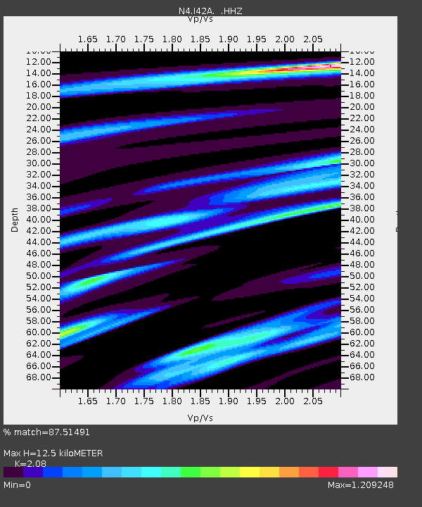
| Estimated Moho Depth: |
12.5 km |
| Estimated Crust Vp/Vs: |
2.08 |
| Assumed Crust Vp: |
6.571 km/s |
| Estimated Crust Vs: |
3.159 km/s |
| Estimated Crust Poisson's Ratio: |
0.35 |
|
| Radial Match: |
87.51491 % |
| Radial Bump: |
198 |
| Transverse Match: |
41.516277 % |
| Transverse Bump: |
359 |
| SOD ConfigId: |
626651 |
| Insert Time: |
2014-04-20 09:33:44.798 +0000 |
| GWidth: |
2.5 |
| Max Bumps: |
400 |
| Tol: |
0.001 |
|

Signal To Noise
| Channel | StoN | STA | LTA |
| N4:I42A: :HHZ:20140113T04:06:48.180002Z | 4.378157 | 1.8481879E-6 | 4.2213833E-7 |
| N4:I42A: :HHN:20140113T04:06:48.180002Z | 4.7748857 | 9.775871E-7 | 2.0473519E-7 |
| N4:I42A: :HHE:20140113T04:06:48.180002Z | 3.018636 | 7.7984254E-7 | 2.583427E-7 |
| Arrivals |
| Ps | 2.2 SECOND |
| PpPs | 5.5 SECOND |
| PsPs/PpSs | 7.7 SECOND |


