You are here: Home > Network List > PB - Plate Boundary Observatory Borehole Seismic Network Stations List
> Station B081 keenwi081bcs2006, Anza, CA, USA > Earthquake Result Viewer
B081 keenwi081bcs2006, Anza, CA, USA - Earthquake Result Viewer
| Earthquake location: |
Puerto Rico Region |
| Earthquake latitude/longitude: |
19.0/-66.8 |
| Earthquake time(UTC): |
2014/01/13 (013) 04:01:03 GMT |
| Earthquake Depth: |
20 km |
| Earthquake Magnitude: |
6.4 MWW, 6.2 MWB, 6.3 MWC, 6.4 MI, 6.4 MWC |
| Earthquake Catalog/Contributor: |
NEIC PDE/NEIC COMCAT |
|
| Network: |
PB Plate Boundary Observatory Borehole Seismic Network |
| Station: |
B081 keenwi081bcs2006, Anza, CA, USA |
| Lat/Lon: |
33.71 N/116.71 W |
| Elevation: |
1467 m |
|
| Distance: |
46.6 deg |
| Az: |
298.655 deg |
| Baz: |
95.229 deg |
| Ray Param: |
0.07051495 |
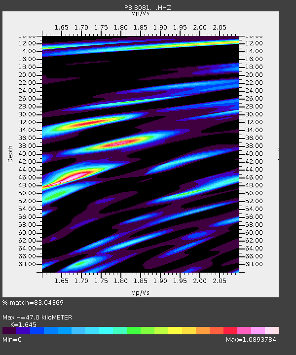
| Estimated Moho Depth: |
47.0 km |
| Estimated Crust Vp/Vs: |
1.64 |
| Assumed Crust Vp: |
6.264 km/s |
| Estimated Crust Vs: |
3.808 km/s |
| Estimated Crust Poisson's Ratio: |
0.21 |
|
| Radial Match: |
83.04369 % |
| Radial Bump: |
400 |
| Transverse Match: |
79.450195 % |
| Transverse Bump: |
400 |
| SOD ConfigId: |
626651 |
| Insert Time: |
2014-04-20 09:35:10.066 +0000 |
| GWidth: |
2.5 |
| Max Bumps: |
400 |
| Tol: |
0.001 |
|

Signal To Noise
| Channel | StoN | STA | LTA |
| PB:B081: :HHZ:20140113T04:08:59.029001Z | 25.669758 | 5.8652482E-8 | 2.2848865E-9 |
| PB:B081: :HH1:20140113T04:08:59.029001Z | 0.94548523 | 9.68216E-10 | 1.0240413E-9 |
| PB:B081: :HH2:20140113T04:08:59.029001Z | 14.17343 | 3.1021692E-8 | 2.1887214E-9 |
| Arrivals |
| Ps | 5.2 SECOND |
| PpPs | 19 SECOND |
| PsPs/PpSs | 24 SECOND |


