You are here: Home > Network List > TA - USArray Transportable Network (new EarthScope stations) Stations List
> Station O03E Paynes Creek, CA, USA > Earthquake Result Viewer
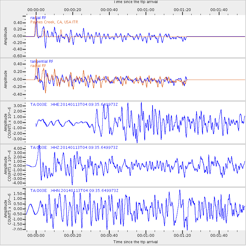
O03E Paynes Creek, CA, USA - Earthquake Result Viewer
*The percent match for this event was below the threshold and hence no stack was calculated.
| Earthquake location: |
Puerto Rico Region |
| Earthquake latitude/longitude: |
19.0/-66.8 |
| Earthquake time(UTC): |
2014/01/13 (013) 04:01:03 GMT |
| Earthquake Depth: |
20 km |
| Earthquake Magnitude: |
6.4 MWW, 6.2 MWB, 6.3 MWC, 6.4 MI, 6.4 MWC |
| Earthquake Catalog/Contributor: |
NEIC PDE/NEIC COMCAT |
|
| Network: |
TA USArray Transportable Network (new EarthScope stations) |
| Station: |
O03E Paynes Creek, CA, USA |
| Lat/Lon: |
40.29 N/121.80 W |
| Elevation: |
967 m |
|
| Distance: |
51.4 deg |
| Az: |
306.705 deg |
| Baz: |
97.465 deg |
| Ray Param: |
$rayparam |
*The percent match for this event was below the threshold and hence was not used in the summary stack. |
|
| Radial Match: |
65.33394 % |
| Radial Bump: |
374 |
| Transverse Match: |
70.854195 % |
| Transverse Bump: |
376 |
| SOD ConfigId: |
626651 |
| Insert Time: |
2014-04-20 09:38:44.505 +0000 |
| GWidth: |
2.5 |
| Max Bumps: |
400 |
| Tol: |
0.001 |
|
Signal To Noise
| Channel | StoN | STA | LTA |
| TA:O03E: :HHZ:20140113T04:09:35.649973Z | 9.422385 | 2.2959894E-6 | 2.436739E-7 |
| TA:O03E: :HHN:20140113T04:09:35.649973Z | 1.0401165 | 4.5025882E-7 | 4.3289268E-7 |
| TA:O03E: :HHE:20140113T04:09:35.649973Z | 3.1870975 | 1.1360298E-6 | 3.5644652E-7 |
| Arrivals |
| Ps | |
| PpPs | |
| PsPs/PpSs | |


