You are here: Home > Network List > TA - USArray Transportable Network (new EarthScope stations) Stations List
> Station T25A Trinidad, CO, USA > Earthquake Result Viewer
T25A Trinidad, CO, USA - Earthquake Result Viewer

| Earthquake location: |
Puerto Rico Region |
| Earthquake latitude/longitude: |
19.0/-66.8 |
| Earthquake time(UTC): |
2014/01/13 (013) 04:01:03 GMT |
| Earthquake Depth: |
20 km |
| Earthquake Magnitude: |
6.4 MWW, 6.2 MWB, 6.3 MWC, 6.4 MI, 6.4 MWC |
| Earthquake Catalog/Contributor: |
NEIC PDE/NEIC COMCAT |
|
| Network: |
TA USArray Transportable Network (new EarthScope stations) |
| Station: |
T25A Trinidad, CO, USA |
| Lat/Lon: |
37.14 N/104.41 W |
| Elevation: |
2017 m |
|
| Distance: |
37.5 deg |
| Az: |
306.692 deg |
| Baz: |
108.344 deg |
| Ray Param: |
0.07610463 |
| Estimated Moho Depth: |
43.5 km |
| Estimated Crust Vp/Vs: |
1.73 |
| Assumed Crust Vp: |
6.316 km/s |
| Estimated Crust Vs: |
3.656 km/s |
| Estimated Crust Poisson's Ratio: |
0.25 |
|
| Radial Match: |
92.47034 % |
| Radial Bump: |
400 |
| Transverse Match: |
78.47699 % |
| Transverse Bump: |
400 |
| SOD ConfigId: |
626651 |
| Insert Time: |
2014-04-20 09:39:01.245 +0000 |
| GWidth: |
2.5 |
| Max Bumps: |
400 |
| Tol: |
0.001 |
|
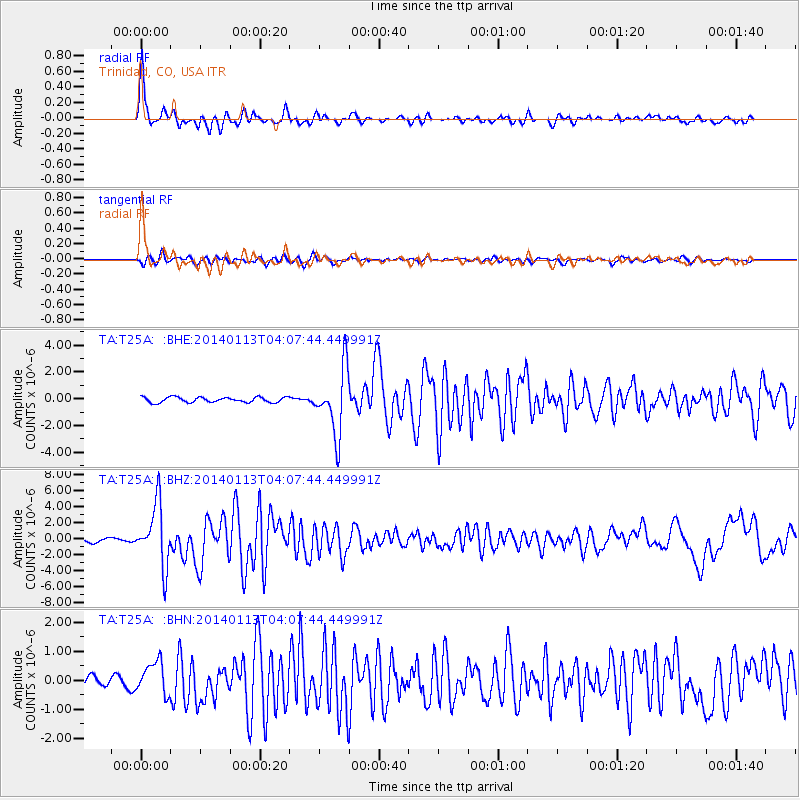
Signal To Noise
| Channel | StoN | STA | LTA |
| TA:T25A: :BHZ:20140113T04:07:44.449991Z | 19.619387 | 3.8351777E-6 | 1.9547899E-7 |
| TA:T25A: :BHN:20140113T04:07:44.449991Z | 3.1581705 | 5.481426E-7 | 1.7356334E-7 |
| TA:T25A: :BHE:20140113T04:07:44.449991Z | 12.594286 | 2.4402327E-6 | 1.9375713E-7 |
| Arrivals |
| Ps | 5.4 SECOND |
| PpPs | 17 SECOND |
| PsPs/PpSs | 23 SECOND |


