You are here: Home > Network List > US - United States National Seismic Network Stations List
> Station DGMT Dagmar, Montana, USA > Earthquake Result Viewer
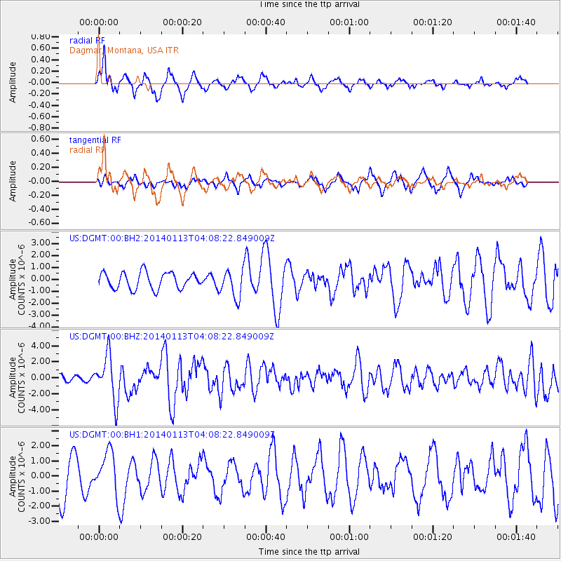
DGMT Dagmar, Montana, USA - Earthquake Result Viewer
*The percent match for this event was below the threshold and hence no stack was calculated.
| Earthquake location: |
Puerto Rico Region |
| Earthquake latitude/longitude: |
19.0/-66.8 |
| Earthquake time(UTC): |
2014/01/13 (013) 04:01:03 GMT |
| Earthquake Depth: |
20 km |
| Earthquake Magnitude: |
6.4 MWW, 6.2 MWB, 6.3 MWC, 6.4 MI, 6.4 MWC |
| Earthquake Catalog/Contributor: |
NEIC PDE/NEIC COMCAT |
|
| Network: |
US United States National Seismic Network |
| Station: |
DGMT Dagmar, Montana, USA |
| Lat/Lon: |
48.47 N/104.20 W |
| Elevation: |
0.0 m |
|
| Distance: |
42.1 deg |
| Az: |
322.914 deg |
| Baz: |
121.004 deg |
| Ray Param: |
$rayparam |
*The percent match for this event was below the threshold and hence was not used in the summary stack. |
|
| Radial Match: |
73.91115 % |
| Radial Bump: |
381 |
| Transverse Match: |
52.354465 % |
| Transverse Bump: |
359 |
| SOD ConfigId: |
626651 |
| Insert Time: |
2014-04-20 09:39:43.957 +0000 |
| GWidth: |
2.5 |
| Max Bumps: |
400 |
| Tol: |
0.001 |
|
Signal To Noise
| Channel | StoN | STA | LTA |
| US:DGMT:00:BHZ:20140113T04:08:22.849009Z | 6.7755103 | 2.9351863E-6 | 4.3320517E-7 |
| US:DGMT:00:BH1:20140113T04:08:22.849009Z | 1.0036061 | 1.4651766E-6 | 1.459912E-6 |
| US:DGMT:00:BH2:20140113T04:08:22.849009Z | 1.7622962 | 1.1965266E-6 | 6.789588E-7 |
| Arrivals |
| Ps | |
| PpPs | |
| PsPs/PpSs | |


