You are here: Home > Network List > US - United States National Seismic Network Stations List
> Station HAWA Hanford, Washington, USA > Earthquake Result Viewer
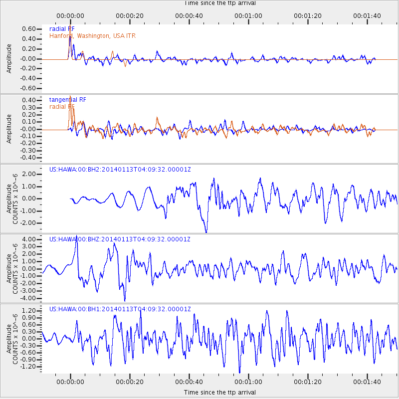
HAWA Hanford, Washington, USA - Earthquake Result Viewer
*The percent match for this event was below the threshold and hence no stack was calculated.
| Earthquake location: |
Puerto Rico Region |
| Earthquake latitude/longitude: |
19.0/-66.8 |
| Earthquake time(UTC): |
2014/01/13 (013) 04:01:03 GMT |
| Earthquake Depth: |
20 km |
| Earthquake Magnitude: |
6.4 MWW, 6.2 MWB, 6.3 MWC, 6.4 MI, 6.4 MWC |
| Earthquake Catalog/Contributor: |
NEIC PDE/NEIC COMCAT |
|
| Network: |
US United States National Seismic Network |
| Station: |
HAWA Hanford, Washington, USA |
| Lat/Lon: |
46.39 N/119.53 W |
| Elevation: |
364 m |
|
| Distance: |
50.9 deg |
| Az: |
314.794 deg |
| Baz: |
104.098 deg |
| Ray Param: |
$rayparam |
*The percent match for this event was below the threshold and hence was not used in the summary stack. |
|
| Radial Match: |
69.63106 % |
| Radial Bump: |
388 |
| Transverse Match: |
65.129616 % |
| Transverse Bump: |
400 |
| SOD ConfigId: |
626651 |
| Insert Time: |
2014-04-20 09:39:59.902 +0000 |
| GWidth: |
2.5 |
| Max Bumps: |
400 |
| Tol: |
0.001 |
|
Signal To Noise
| Channel | StoN | STA | LTA |
| US:HAWA:00:BHZ:20140113T04:09:32.00001Z | 5.697484 | 1.9206307E-6 | 3.3710157E-7 |
| US:HAWA:00:BH1:20140113T04:09:32.00001Z | 1.1494505 | 3.0048284E-7 | 2.6141433E-7 |
| US:HAWA:00:BH2:20140113T04:09:32.00001Z | 1.7481391 | 6.289789E-7 | 3.5979912E-7 |
| Arrivals |
| Ps | |
| PpPs | |
| PsPs/PpSs | |


