You are here: Home > Network List > US - United States National Seismic Network Stations List
> Station MNTX Cornudas Mountains, Texas, USA > Earthquake Result Viewer
MNTX Cornudas Mountains, Texas, USA - Earthquake Result Viewer

| Earthquake location: |
Puerto Rico Region |
| Earthquake latitude/longitude: |
19.0/-66.8 |
| Earthquake time(UTC): |
2014/01/13 (013) 04:01:03 GMT |
| Earthquake Depth: |
20 km |
| Earthquake Magnitude: |
6.4 MWW, 6.2 MWB, 6.3 MWC, 6.4 MI, 6.4 MWC |
| Earthquake Catalog/Contributor: |
NEIC PDE/NEIC COMCAT |
|
| Network: |
US United States National Seismic Network |
| Station: |
MNTX Cornudas Mountains, Texas, USA |
| Lat/Lon: |
31.70 N/105.38 W |
| Elevation: |
404 m |
|
| Distance: |
36.9 deg |
| Az: |
297.655 deg |
| Baz: |
100.589 deg |
| Ray Param: |
0.076420195 |
| Estimated Moho Depth: |
26.0 km |
| Estimated Crust Vp/Vs: |
2.10 |
| Assumed Crust Vp: |
6.361 km/s |
| Estimated Crust Vs: |
3.036 km/s |
| Estimated Crust Poisson's Ratio: |
0.35 |
|
| Radial Match: |
95.52314 % |
| Radial Bump: |
330 |
| Transverse Match: |
87.4677 % |
| Transverse Bump: |
400 |
| SOD ConfigId: |
626651 |
| Insert Time: |
2014-04-20 09:40:16.751 +0000 |
| GWidth: |
2.5 |
| Max Bumps: |
400 |
| Tol: |
0.001 |
|
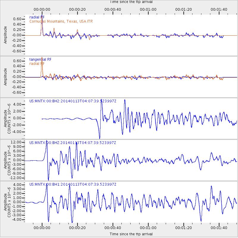
Signal To Noise
| Channel | StoN | STA | LTA |
| US:MNTX:00:BHZ:20140113T04:07:39.523997Z | 37.65866 | 6.2978156E-6 | 1.672342E-7 |
| US:MNTX:00:BH1:20140113T04:07:39.523997Z | 15.044037 | 2.0880188E-6 | 1.3879378E-7 |
| US:MNTX:00:BH2:20140113T04:07:39.523997Z | 24.001806 | 2.7542917E-6 | 1.1475351E-7 |
| Arrivals |
| Ps | 4.8 SECOND |
| PpPs | 12 SECOND |
| PsPs/PpSs | 17 SECOND |


