You are here: Home > Network List > US - United States National Seismic Network Stations List
> Station WMOK Wichita Mountains, Oklahoma, USA > Earthquake Result Viewer
WMOK Wichita Mountains, Oklahoma, USA - Earthquake Result Viewer
| Earthquake location: |
Puerto Rico Region |
| Earthquake latitude/longitude: |
19.0/-66.8 |
| Earthquake time(UTC): |
2014/01/13 (013) 04:01:03 GMT |
| Earthquake Depth: |
20 km |
| Earthquake Magnitude: |
6.4 MWW, 6.2 MWB, 6.3 MWC, 6.4 MI, 6.4 MWC |
| Earthquake Catalog/Contributor: |
NEIC PDE/NEIC COMCAT |
|
| Network: |
US United States National Seismic Network |
| Station: |
WMOK Wichita Mountains, Oklahoma, USA |
| Lat/Lon: |
34.74 N/98.78 W |
| Elevation: |
486 m |
|
| Distance: |
32.3 deg |
| Az: |
305.409 deg |
| Baz: |
110.582 deg |
| Ray Param: |
0.078671254 |
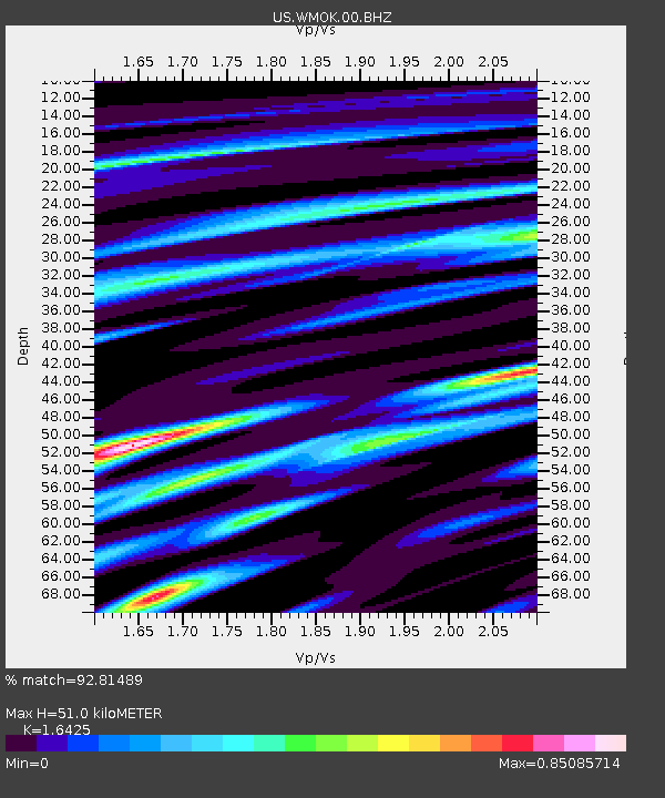
| Estimated Moho Depth: |
51.0 km |
| Estimated Crust Vp/Vs: |
1.64 |
| Assumed Crust Vp: |
6.315 km/s |
| Estimated Crust Vs: |
3.845 km/s |
| Estimated Crust Poisson's Ratio: |
0.21 |
|
| Radial Match: |
92.81489 % |
| Radial Bump: |
291 |
| Transverse Match: |
72.40478 % |
| Transverse Bump: |
400 |
| SOD ConfigId: |
626651 |
| Insert Time: |
2014-04-20 09:40:37.925 +0000 |
| GWidth: |
2.5 |
| Max Bumps: |
400 |
| Tol: |
0.001 |
|

Signal To Noise
| Channel | StoN | STA | LTA |
| US:WMOK:00:BHZ:20140113T04:07:00.525004Z | 17.609539 | 3.4333825E-6 | 1.9497287E-7 |
| US:WMOK:00:BH1:20140113T04:07:00.525004Z | 4.8031917 | 1.0920982E-6 | 2.2736928E-7 |
| US:WMOK:00:BH2:20140113T04:07:00.525004Z | 7.761714 | 1.7105632E-6 | 2.2038472E-7 |
| Arrivals |
| Ps | 5.6 SECOND |
| PpPs | 20 SECOND |
| PsPs/PpSs | 25 SECOND |


