You are here: Home > Network List > CI - Caltech Regional Seismic Network Stations List
> Station CIA CIA, Avalon Catalina Island, CA, USA > Earthquake Result Viewer
CIA CIA, Avalon Catalina Island, CA, USA - Earthquake Result Viewer
| Earthquake location: |
Near Coast Of Peru |
| Earthquake latitude/longitude: |
-16.3/-73.6 |
| Earthquake time(UTC): |
2001/06/23 (174) 20:33:14 GMT |
| Earthquake Depth: |
33 km |
| Earthquake Magnitude: |
6.7 MB, 8.2 MS, 8.4 MW, 7.8 ME |
| Earthquake Catalog/Contributor: |
WHDF/NEIC |
|
| Network: |
CI Caltech Regional Seismic Network |
| Station: |
CIA CIA, Avalon Catalina Island, CA, USA |
| Lat/Lon: |
33.40 N/118.41 W |
| Elevation: |
467 m |
|
| Distance: |
65.3 deg |
| Az: |
319.572 deg |
| Baz: |
131.877 deg |
| Ray Param: |
0.058309402 |
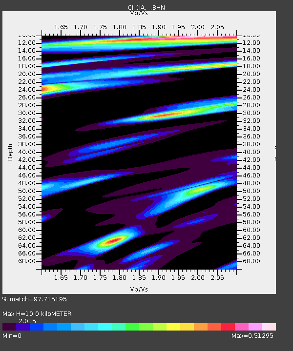
| Estimated Moho Depth: |
10.0 km |
| Estimated Crust Vp/Vs: |
2.02 |
| Assumed Crust Vp: |
6.048 km/s |
| Estimated Crust Vs: |
3.001 km/s |
| Estimated Crust Poisson's Ratio: |
0.34 |
|
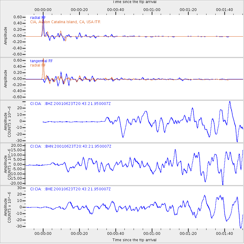
| Radial Match: |
97.715195 % |
| Radial Bump: |
216 |
| Transverse Match: |
84.32767 % |
| Transverse Bump: |
400 |
| SOD ConfigId: |
3787 |
| Insert Time: |
2010-02-25 20:55:33.207 +0000 |
| GWidth: |
2.5 |
| Max Bumps: |
400 |
| Tol: |
0.001 |
|
Signal To Noise
| Channel | StoN | STA | LTA |
| CI:CIA: :BHN:20010623T20:43:21.950007Z | 2.2783463 | 6.448176E-7 | 2.8302E-7 |
| CI:CIA: :BHE:20010623T20:43:21.950007Z | 2.3242514 | 7.9377617E-7 | 3.4151907E-7 |
| CI:CIA: :BHZ:20010623T20:43:21.950007Z | 5.611998 | 1.4671126E-6 | 2.6142428E-7 |
| Arrivals |
| Ps | 1.7 SECOND |
| PpPs | 4.8 SECOND |
| PsPs/PpSs | 6.6 SECOND |


