You are here: Home > Network List > TA - USArray Transportable Network (new EarthScope stations) Stations List
> Station H63A New Sharon, ME, USA > Earthquake Result Viewer
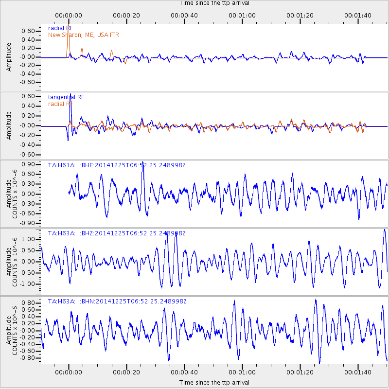
H63A New Sharon, ME, USA - Earthquake Result Viewer
*The percent match for this event was below the threshold and hence no stack was calculated.
| Earthquake location: |
Gulf Of California |
| Earthquake latitude/longitude: |
24.4/-109.1 |
| Earthquake time(UTC): |
2014/12/25 (359) 06:45:42 GMT |
| Earthquake Depth: |
10 km |
| Earthquake Magnitude: |
5.2 MW, 5.1 mb, 5.2 Md |
| Earthquake Catalog/Contributor: |
ISC/ISC |
|
| Network: |
TA USArray Transportable Network (new EarthScope stations) |
| Station: |
H63A New Sharon, ME, USA |
| Lat/Lon: |
44.66 N/70.04 W |
| Elevation: |
109 m |
|
| Distance: |
37.5 deg |
| Az: |
47.577 deg |
| Baz: |
250.559 deg |
| Ray Param: |
$rayparam |
*The percent match for this event was below the threshold and hence was not used in the summary stack. |
|
| Radial Match: |
44.330544 % |
| Radial Bump: |
400 |
| Transverse Match: |
69.07911 % |
| Transverse Bump: |
400 |
| SOD ConfigId: |
3390531 |
| Insert Time: |
2019-04-15 19:06:04.862 +0000 |
| GWidth: |
2.5 |
| Max Bumps: |
400 |
| Tol: |
0.001 |
|
Signal To Noise
| Channel | StoN | STA | LTA |
| TA:H63A: :BHZ:20141225T06:52:25.248998Z | 1.1477013 | 4.5982443E-7 | 4.006482E-7 |
| TA:H63A: :BHN:20141225T06:52:25.248998Z | 0.986947 | 3.072834E-7 | 3.1134738E-7 |
| TA:H63A: :BHE:20141225T06:52:25.248998Z | 0.55138856 | 1.5228044E-7 | 2.7617625E-7 |
| Arrivals |
| Ps | |
| PpPs | |
| PsPs/PpSs | |


