You are here: Home > Network List > CI - Caltech Regional Seismic Network Stations List
> Station MPM Manuel Prospect Mine, California, USA > Earthquake Result Viewer
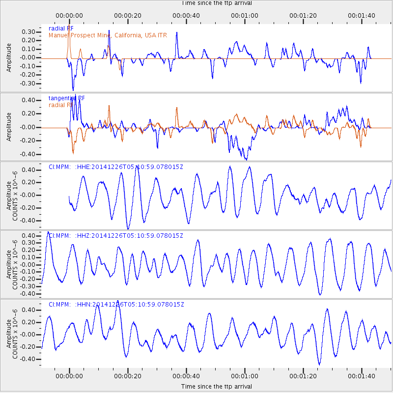
MPM Manuel Prospect Mine, California, USA - Earthquake Result Viewer
*The percent match for this event was below the threshold and hence no stack was calculated.
| Earthquake location: |
Vanuatu Islands |
| Earthquake latitude/longitude: |
-16.9/168.1 |
| Earthquake time(UTC): |
2014/12/26 (360) 04:58:49 GMT |
| Earthquake Depth: |
71 km |
| Earthquake Magnitude: |
5.1 MW, 4.6 mb |
| Earthquake Catalog/Contributor: |
ISC/ISC |
|
| Network: |
CI Caltech Regional Seismic Network |
| Station: |
MPM Manuel Prospect Mine, California, USA |
| Lat/Lon: |
36.06 N/117.49 W |
| Elevation: |
185 m |
|
| Distance: |
87.8 deg |
| Az: |
51.377 deg |
| Baz: |
247.399 deg |
| Ray Param: |
$rayparam |
*The percent match for this event was below the threshold and hence was not used in the summary stack. |
|
| Radial Match: |
52.768017 % |
| Radial Bump: |
400 |
| Transverse Match: |
48.860878 % |
| Transverse Bump: |
400 |
| SOD ConfigId: |
3390531 |
| Insert Time: |
2019-04-15 19:09:43.957 +0000 |
| GWidth: |
2.5 |
| Max Bumps: |
400 |
| Tol: |
0.001 |
|
Signal To Noise
| Channel | StoN | STA | LTA |
| CI:MPM: :HHZ:20141226T05:10:59.078015Z | 0.7131311 | 1.8791773E-7 | 2.6351077E-7 |
| CI:MPM: :HHN:20141226T05:10:59.078015Z | 0.9007439 | 2.0807106E-7 | 2.3099913E-7 |
| CI:MPM: :HHE:20141226T05:10:59.078015Z | 0.7315071 | 1.7269215E-7 | 2.360772E-7 |
| Arrivals |
| Ps | |
| PpPs | |
| PsPs/PpSs | |


