You are here: Home > Network List > US - United States National Seismic Network Stations List
> Station GLMI Grayling, Michigan, USA > Earthquake Result Viewer
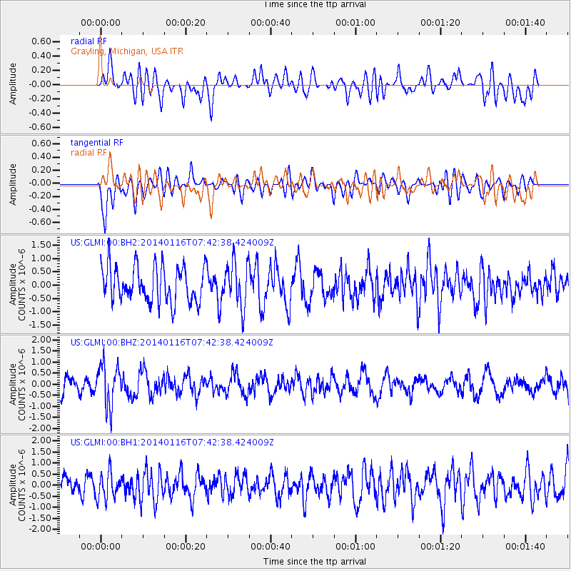
GLMI Grayling, Michigan, USA - Earthquake Result Viewer
*The percent match for this event was below the threshold and hence no stack was calculated.
| Earthquake location: |
Andreanof Islands, Aleutian Is. |
| Earthquake latitude/longitude: |
51.2/-179.2 |
| Earthquake time(UTC): |
2014/01/16 (016) 07:33:09 GMT |
| Earthquake Depth: |
27 km |
| Earthquake Magnitude: |
5.5 MWB, 5.2 ML, 5.5 ML, 5.6 MWC |
| Earthquake Catalog/Contributor: |
NEIC PDE/NEIC COMCAT |
|
| Network: |
US United States National Seismic Network |
| Station: |
GLMI Grayling, Michigan, USA |
| Lat/Lon: |
44.82 N/84.62 W |
| Elevation: |
387 m |
|
| Distance: |
59.3 deg |
| Az: |
55.543 deg |
| Baz: |
313.158 deg |
| Ray Param: |
$rayparam |
*The percent match for this event was below the threshold and hence was not used in the summary stack. |
|
| Radial Match: |
54.70977 % |
| Radial Bump: |
400 |
| Transverse Match: |
63.80226 % |
| Transverse Bump: |
400 |
| SOD ConfigId: |
626651 |
| Insert Time: |
2014-04-20 10:14:01.119 +0000 |
| GWidth: |
2.5 |
| Max Bumps: |
400 |
| Tol: |
0.001 |
|
Signal To Noise
| Channel | StoN | STA | LTA |
| US:GLMI:00:BHZ:20140116T07:42:38.424009Z | 2.3094635 | 9.4779546E-7 | 4.1039638E-7 |
| US:GLMI:00:BH1:20140116T07:42:38.424009Z | 1.3857516 | 6.0113706E-7 | 4.3379856E-7 |
| US:GLMI:00:BH2:20140116T07:42:38.424009Z | 1.2710439 | 8.451711E-7 | 6.649425E-7 |
| Arrivals |
| Ps | |
| PpPs | |
| PsPs/PpSs | |


