You are here: Home > Network List > AV - Alaska Volcano Observatory Stations List
> Station MAPS Pakushin Southeast, Makushin Volcano, Alaska > Earthquake Result Viewer
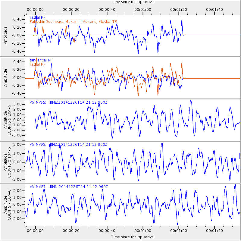
MAPS Pakushin Southeast, Makushin Volcano, Alaska - Earthquake Result Viewer
*The percent match for this event was below the threshold and hence no stack was calculated.
| Earthquake location: |
Java, Indonesia |
| Earthquake latitude/longitude: |
-7.1/107.3 |
| Earthquake time(UTC): |
2014/12/26 (360) 14:08:42 GMT |
| Earthquake Depth: |
114 km |
| Earthquake Magnitude: |
4.3 mb, 3.8 mb, 3.9 mb1, 3.7 mb1mx, 4.2 mbtmp, 3.4 MS, 3.5 Ms1, 2.7 ms1mx |
| Earthquake Catalog/Contributor: |
ISC/ISC |
|
| Network: |
AV Alaska Volcano Observatory |
| Station: |
MAPS Pakushin Southeast, Makushin Volcano, Alaska |
| Lat/Lon: |
53.81 N/166.94 W |
| Elevation: |
333 m |
|
| Distance: |
93.2 deg |
| Az: |
36.325 deg |
| Baz: |
262.443 deg |
| Ray Param: |
$rayparam |
*The percent match for this event was below the threshold and hence was not used in the summary stack. |
|
| Radial Match: |
52.878754 % |
| Radial Bump: |
400 |
| Transverse Match: |
54.608154 % |
| Transverse Bump: |
400 |
| SOD ConfigId: |
3390531 |
| Insert Time: |
2019-04-15 19:19:44.185 +0000 |
| GWidth: |
2.5 |
| Max Bumps: |
400 |
| Tol: |
0.001 |
|
Signal To Noise
| Channel | StoN | STA | LTA |
| AV:MAPS: :BHZ:20141226T14:21:12.960Z | 1.0057545 | 9.2254726E-7 | 9.172689E-7 |
| AV:MAPS: :BHN:20141226T14:21:12.960Z | 0.9952337 | 8.951699E-7 | 8.9945695E-7 |
| AV:MAPS: :BHE:20141226T14:21:12.960Z | 2.1448605 | 2.04543E-6 | 9.536424E-7 |
| Arrivals |
| Ps | |
| PpPs | |
| PsPs/PpSs | |


