You are here: Home > Network List > AU - Australian Seismological Centre Stations List
> Station CTA Charters Towers, Queensland > Earthquake Result Viewer
CTA Charters Towers, Queensland - Earthquake Result Viewer
| Earthquake location: |
Tonga Islands |
| Earthquake latitude/longitude: |
-15.1/-174.7 |
| Earthquake time(UTC): |
2014/01/21 (021) 01:29:07 GMT |
| Earthquake Depth: |
6.1 km |
| Earthquake Magnitude: |
6.1 MWW, 6.1 MWB, 6.2 MWC, 6.5 MI |
| Earthquake Catalog/Contributor: |
NEIC PDE/NEIC COMCAT |
|
| Network: |
AU Australian Seismological Centre |
| Station: |
CTA Charters Towers, Queensland |
| Lat/Lon: |
20.09 S/146.25 E |
| Elevation: |
426 m |
|
| Distance: |
37.5 deg |
| Az: |
256.679 deg |
| Baz: |
88.873 deg |
| Ray Param: |
0.07611159 |
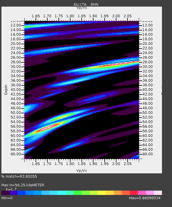
| Estimated Moho Depth: |
56.25 km |
| Estimated Crust Vp/Vs: |
1.70 |
| Assumed Crust Vp: |
6.522 km/s |
| Estimated Crust Vs: |
3.836 km/s |
| Estimated Crust Poisson's Ratio: |
0.24 |
|
| Radial Match: |
92.90055 % |
| Radial Bump: |
246 |
| Transverse Match: |
66.898 % |
| Transverse Bump: |
400 |
| SOD ConfigId: |
626651 |
| Insert Time: |
2014-04-20 10:27:37.570 +0000 |
| GWidth: |
2.5 |
| Max Bumps: |
400 |
| Tol: |
0.001 |
|

Signal To Noise
| Channel | StoN | STA | LTA |
| AU:CTA: :BHZ:20140121T01:35:50.625Z | 3.1992266 | 6.166707E-7 | 1.9275619E-7 |
| AU:CTA: :BHN:20140121T01:35:50.625Z | 1.6770487 | 1.478985E-7 | 8.818974E-8 |
| AU:CTA: :BHE:20140121T01:35:50.625Z | 3.2923474 | 4.2968938E-7 | 1.3051155E-7 |
| Arrivals |
| Ps | 6.5 SECOND |
| PpPs | 22 SECOND |
| PsPs/PpSs | 28 SECOND |


