You are here: Home > Network List > II - Global Seismograph Network (GSN - IRIS/IDA) Stations List
> Station WRAB Tennant Creek, NT, Australia > Earthquake Result Viewer
WRAB Tennant Creek, NT, Australia - Earthquake Result Viewer
| Earthquake location: |
Tonga Islands |
| Earthquake latitude/longitude: |
-15.1/-174.7 |
| Earthquake time(UTC): |
2014/01/21 (021) 01:29:07 GMT |
| Earthquake Depth: |
6.1 km |
| Earthquake Magnitude: |
6.1 MWW, 6.1 MWB, 6.2 MWC, 6.5 MI |
| Earthquake Catalog/Contributor: |
NEIC PDE/NEIC COMCAT |
|
| Network: |
II Global Seismograph Network (GSN - IRIS/IDA) |
| Station: |
WRAB Tennant Creek, NT, Australia |
| Lat/Lon: |
19.93 S/134.36 E |
| Elevation: |
366 m |
|
| Distance: |
48.7 deg |
| Az: |
256.648 deg |
| Baz: |
92.908 deg |
| Ray Param: |
0.06921106 |
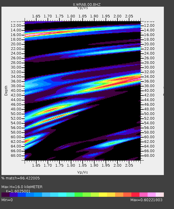
| Estimated Moho Depth: |
16.0 km |
| Estimated Crust Vp/Vs: |
1.60 |
| Assumed Crust Vp: |
6.642 km/s |
| Estimated Crust Vs: |
4.145 km/s |
| Estimated Crust Poisson's Ratio: |
0.18 |
|
| Radial Match: |
96.422005 % |
| Radial Bump: |
377 |
| Transverse Match: |
78.98909 % |
| Transverse Bump: |
400 |
| SOD ConfigId: |
626651 |
| Insert Time: |
2014-04-20 10:32:40.416 +0000 |
| GWidth: |
2.5 |
| Max Bumps: |
400 |
| Tol: |
0.001 |
|
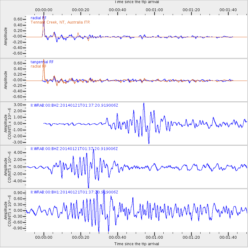
Signal To Noise
| Channel | StoN | STA | LTA |
| II:WRAB:00:BHZ:20140121T01:37:20.919006Z | 4.9256287 | 6.499488E-7 | 1.3195245E-7 |
| II:WRAB:00:BH1:20140121T01:37:20.919006Z | 1.2219006 | 1.1067512E-7 | 9.05762E-8 |
| II:WRAB:00:BH2:20140121T01:37:20.919006Z | 3.7846699 | 3.380108E-7 | 8.931051E-8 |
| Arrivals |
| Ps | 1.6 SECOND |
| PpPs | 5.8 SECOND |
| PsPs/PpSs | 7.4 SECOND |


